350, Hythe Road, building in Ashford, Kent, UK
Posizione: Ashford
Coordinate GPS: 51.14251,0.89799
Ultimo aggiornamento: 25 novembre 2023 alle 01:28
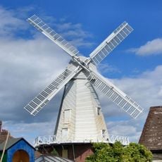
New Mill
317 m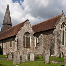
Church of St Mary the Virgin
612 m
96, Church Road
348 m
94, Church Road
362 m
88, Church Road
364 m
The William Harvey Public House
582 m
2-8, Blackwall Road
791 m
56, Silver Hill Road
642 m
54, Silver Hill Road
624 m
Barn To North West Of Court Lodge
662 m
The Rose Inn
601 m
33 And 35, Silver Hill Road
604 m
Old National School St Marys Hall
446 m
50-52, Romney Road
439 m
Dunn's Hill House
426 m
38, Kennington Road
650 m
Barn At Court Lodge To North West Of The House And Adjoining The Preceding Barn On The West
654 m
52-60, Kennington Road
657 m
Holly Tree House
657 m
Statue of William Harvey in Grounds of William Harvey Public House
600 m
13-19, Lees Road
672 m
Rosemary
672 m
Lees House
675 m
Court Lodge
688 m
Lees Farmhouse
705 m
Shepway
713 m
Stables To Lees Farmhouse
721 m
Brisley Rise
758 mRecensioni
Ha visitato questo luogo? Tocchi le stelle per valutarlo e condividere la Sua esperienza o foto con la community! Provalo ora! Puoi annullarlo in qualsiasi momento.
Scopri tesori nascosti ad ogni viaggio!
Da piccoli caffè caratteristici a panorami nascosti, fuggi dalla folla e scova i posti che fanno davvero per te. La nostra app ti semplifica tutto: ricerca vocale, filtri furbi, percorsi ottimizzati e dritte autentiche da viaggiatori di tutto il mondo. Scaricala subito per vivere l'avventura sul tuo smartphone!

Un nuovo approccio alla scoperta turistica❞
— Le Figaro
Tutti i luoghi che meritano di essere esplorati❞
— France Info
Un’escursione su misura in pochi clic❞
— 20 Minutes