
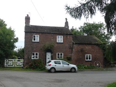
Stone Cottage and attached outbuilding and boundary wall
Stone Cottage and attached outbuilding and boundary wall, Grade II listed cottage in Shotwick, Cheshire West and Chester, Cheshire, UK
Posizione: Puddington
Coordinate GPS: 53.23944,-2.99348
Ultimo aggiornamento: 6 marzo 2025 alle 19:22

RAF Sealand
1.9 km
Shotwick Castle
1.8 km
Shotwick House
2.5 km
St Michael's Church, Shotwick
130 m
Shotwick Hall
213 m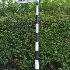
Footpath Guidepost At Junction With Parkgate Road
2.4 km
Gates, gatepiers and churchyard wall along north side of Shotwick Lane
149 m
Front garden walls and gatepiers at Shotwick Hall
212 m
Tombchest of Robert and Martha Ellison, 10 metres southwest of south corner of tower of Church of St Michael
160 m
Manor Farmhouse
23 m
L-shaped ranges of farm buildings 60 metres north of Shotwick Hall
284 m
Footpath Guidepost At Junction Of Pipers Lane Opposite The White House
1.9 km
Granary 30 metres east of Shotwicklodge Farmhouse
1.4 km
Sundial in the churchyard of St Michael
152 m
Greyhound Farmhouse
36 m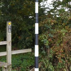
Footpath guidepost 50m east of Heath farmhouse
2.5 km
Tombchest of James Phillips, 2 metres south of the sundial in the Churchyard of St Michael
154 m
Former kitchen or bakehouse attached to north east corner of Shotwick Hall
231 m
Tombchest of Rev M Reay and 4 children, 8 metres south of south porch of Church of St Michael
145 m
Tombchest of John Nevett Bennett, 5 metres west of south porch of St Michael's Church
148 m
Tombchest of William Briscoe (died 1723) and others, 4 metres west of priest's door to St Michael's Church
136 m
Vicarage Farmhouse
79 m
Footpath Guidepost 5 Metres North Of Top Lodge
1.7 km
Barn 70 metres north east of Shotwicklodge Farmhouse
1.4 km
Tombchest of William Briscoe (died 1704) and others, 5 metres southwest of priest's door to St Michael's Church
136 m
North Pair of Aircraft Hangars
1.6 km
South Pair of Aircraft Hangars
1.7 km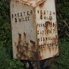
Milepost, Parkgate Road, Woodbank
2.2 kmRecensioni
Ha visitato questo luogo? Tocchi le stelle per valutarlo e condividere la Sua esperienza o foto con la community! Provalo ora! Puoi annullarlo in qualsiasi momento.
Scopri tesori nascosti ad ogni viaggio!
Da piccoli caffè caratteristici a panorami nascosti, fuggi dalla folla e scova i posti che fanno davvero per te. La nostra app ti semplifica tutto: ricerca vocale, filtri furbi, percorsi ottimizzati e dritte autentiche da viaggiatori di tutto il mondo. Scaricala subito per vivere l'avventura sul tuo smartphone!

Un nuovo approccio alla scoperta turistica❞
— Le Figaro
Tutti i luoghi che meritano di essere esplorati❞
— France Info
Un’escursione su misura in pochi clic❞
— 20 Minutes