
Lower Meadows Meadows, architectural structure in Smeeth, Ashford, Kent, UK
Posizione: Smeeth
Coordinate GPS: 51.11844,0.96065
Ultimo aggiornamento: 24 novembre 2025 alle 08:48
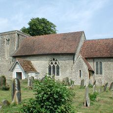
Church of St Mary
78 m
Boundary And Garden Walls To North And West Of Church House, With Gateway
110 m
Barn About 20 Metres South Of Court Farmhouse
823 m
Old Post Office
911 m
Ridgeway Cottages
435 m
Smeeth Hill House
160 m
Church Cottages
81 m
Park Cottage
923 m
Evegate Manor
814 m
Barn And Courtyard Walls 25 Metres To North Of Church Farmhouse
101 m
Stable/Outbuildings About 10 Metres South West Of Homelands
845 m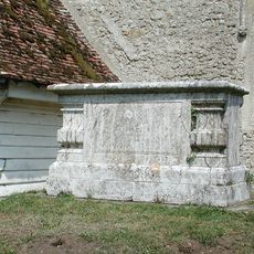
Chest Tomb To Thomas Wyborn, About 2 Metres South Of Church Of St Mary
73 m
Chest Tomb To Elizabeth Ball About 15 Metres East Of Church Of St Mary
54 m
Homelands
845 m
Group Of 4 Chest Tombs, 2 Barrel Tombs And Headstones About 5 Metres South West Of Church Of St Mary
93 m
Court Farmhouse
844 m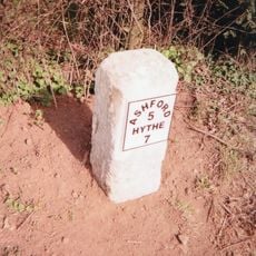
Milestone, Hythe Road, 40m E of Smeeth Crossroads
192 m
Ridgeway House
737 m
Ivydene
452 m
Morley Cottage
806 m
Stable/Outbuildings About 25 Metres South West Of Homelands
844 m
Sundial About 10 Metres South Of Church Of St Mary
83 m
Church House
123 m
Church Farmhouse
103 m
Outbuilding About 15 Metres East Of Ivydene
439 m
Lyncroft Stores
916 m
Holly Cottage
909 m
Smeeth War Memorial
123 mRecensioni
Ha visitato questo luogo? Tocchi le stelle per valutarlo e condividere la Sua esperienza o foto con la community! Provalo ora! Puoi annullarlo in qualsiasi momento.
Scopri tesori nascosti ad ogni viaggio!
Da piccoli caffè caratteristici a panorami nascosti, fuggi dalla folla e scova i posti che fanno davvero per te. La nostra app ti semplifica tutto: ricerca vocale, filtri furbi, percorsi ottimizzati e dritte autentiche da viaggiatori di tutto il mondo. Scaricala subito per vivere l'avventura sul tuo smartphone!

Un nuovo approccio alla scoperta turistica❞
— Le Figaro
Tutti i luoghi che meritano di essere esplorati❞
— France Info
Un’escursione su misura in pochi clic❞
— 20 Minutes