
Willmore Surface
Posizione: County Durham
Creatore: Peter Sales
Accessibilità: Accesible en silla de ruedas
Realizzato in: granite
Creatore: Peter Sales
Sito web: https://dur.ac.uk/news/newsitem/?itemno=14164
Coordinate GPS: 54.76757,-1.57268
Ultimo aggiornamento: 11 novembre 2025 alle 15:19
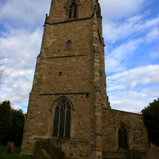
Church of St Oswald
426 m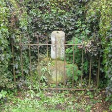
Charley's Cross At West Corner Of Junction With Church Street
179 m
Palatine Reception
124 m
Counts House
409 m
Ice House North Of Count's House
424 m
10, South Bailey
462 m
75, Hallgarth Street
463 m
Wall Behind Nos. 12 And 12a
451 m
37, Hallgarth Street
413 m
54-56, Hallgarth Street
364 m
73, Hallgarth Street
452 m
St Cuthbert's Society
461 m
9, South Bailey
468 m
11, South Bailey
460 m
21-32, Hallgarth Street
458 m
67, Hallgarth Street
416 m
Garden Wall South Of No. 5
468 m
Wall Behind St.john's College From Nos. 1 To 11 Consecutive, And Garden House Attached Behind No.11
437 m
59, Hallgarth Street
379 m
68 And 69, Hallgarth Street
425 m
58, Hallgarth Street
374 m
70, Hallgarth Street
433 m
Durham University Library
72 m
What Lies Beneath Us
138 m
Cry For Justice
69 m
Durham Sundial
82 m
St. Oswald's Arch
334 m
Punto di vista panoramico
300 mRecensioni
Ha visitato questo luogo? Tocchi le stelle per valutarlo e condividere la Sua esperienza o foto con la community! Provalo ora! Puoi annullarlo in qualsiasi momento.
Scopri tesori nascosti ad ogni viaggio!
Da piccoli caffè caratteristici a panorami nascosti, fuggi dalla folla e scova i posti che fanno davvero per te. La nostra app ti semplifica tutto: ricerca vocale, filtri furbi, percorsi ottimizzati e dritte autentiche da viaggiatori di tutto il mondo. Scaricala subito per vivere l'avventura sul tuo smartphone!

Un nuovo approccio alla scoperta turistica❞
— Le Figaro
Tutti i luoghi che meritano di essere esplorati❞
— France Info
Un’escursione su misura in pochi clic❞
— 20 Minutes