Kohlbornstein

Accedi al tuo account

AroundUs è una mappa collaborativa di luoghi interessanti, costruita da esploratori curiosi come te. Cresce con ogni recensione, storia e foto che condividi.
Accedi per salvare i tuoi posti preferiti, contribuire con nuovi luoghi e creare percorsi personalizzati.
Continuando, accetti i nostri Termini e Condizioni e la nostra Informativa sulla Privacy

Kohlbornstein

Aggiungi alla collezione
Mappa
Suggerisci una modifica
Condividere

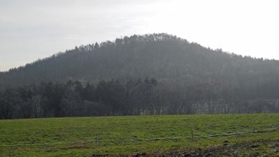
Kohlbornstein, Vetta a Gohrisch, Germania.

Il Kohlbornstein si eleva 378 metri sul livello del mare nella Svizzera Sassone, presentando formazioni di arenaria degli strati geologici Postelwitz e Schrammstein.

Nel 1884, l'Associazione Montana della Svizzera Sassone costruì un sentiero fino alla vetta, seguito da una visita del Re Alberto e della Regina Carola nel 1886.

Il sentiero Malerweg passa a nord del Kohlbornstein, collegando i villaggi di Kleinhennersdorf e Krippen attraverso percorsi segnati nelle Montagne di Arenaria dell'Elba.

Gli escursionisti possono accedere alla vetta esclusivamente da sud-ovest, con un percorso di 11.3 chilometri che richiede circa 3 ore e 40 minuti.

Il nome Kohlbornstein deriva dalla sorgente Kohlborn situata alla base nord della vetta, dove l'acqua emerge dalle formazioni di arenaria.

Posizione: Gohrisch

Coordinate GPS: 50.89800,14.15474

Ultimo aggiornamento: 17 marzo 2025 alle 20:48

La vista
La vista
QRCode
Intorno a questo luogo
Mostra la mappa completa
Reinhardtsdorf Sandstone
Germania

Reinhardtsdorf Sandstone

1.1 km
Dorfkirche Krippen
Germania

Dorfkirche Krippen

1.3 km
Bogenbrücke über den Krippenbach Friedrich-Gottlob-Keller-Straße 71 (bei)
Germania

Bogenbrücke über den Krippenbach Friedrich-Gottlob-Keller-Straße 71 (bei)

981 m
Schule Friedrich-Gottlob-Keller-Straße 39
Germania

Schule Friedrich-Gottlob-Keller-Straße 39

1.5 km
Friedrich-Gottlob-Keller-Straße 78
Germania

Friedrich-Gottlob-Keller-Straße 78

976 m
Bogenbrücke über den Krippenbach Friedrich-Gottlob-Keller-Straße 63 (bei)
Germania

Bogenbrücke über den Krippenbach Friedrich-Gottlob-Keller-Straße 63 (bei)

1.1 km
Alte Schule
Germania

Alte Schule

1.3 km
Wohnhaus des Friedrich Gottlob Keller Friedrich-Gottlob-Keller-Straße 76
Germania

Wohnhaus des Friedrich Gottlob Keller Friedrich-Gottlob-Keller-Straße 76

961 m
Berghangweg 17
Germania

Berghangweg 17

1.5 km
Postgebäude Friedrich-Gottlob-Keller-Straße 56
Germania

Postgebäude Friedrich-Gottlob-Keller-Straße 56

1.2 km
Wohnhaus Friedrich-Gottlob-Keller-Straße 79
Germania

Wohnhaus Friedrich-Gottlob-Keller-Straße 79

982 m
Wohnhaus Friedrich-Gottlob-Keller-Straße 27
Germania

Wohnhaus Friedrich-Gottlob-Keller-Straße 27

1.5 km
Liethenmühle
Germania

Liethenmühle

604 m
Wohnhaus Friedrich-Gottlob-Keller-Straße 64
Germania

Wohnhaus Friedrich-Gottlob-Keller-Straße 64

1.1 km
Wohnhaus Friedrich-Gottlob-Keller-Straße 48
Germania

Wohnhaus Friedrich-Gottlob-Keller-Straße 48

1.3 km
Sachgesamtheit Ev. Pfarrkirche und Kirchhof Krippen mit folgenden Einzeldenkmalen: neoromanische Saalkirche mit Südwestturm, Kriegerdenkmal für die Gefallenen des Ersten Weltkrieges, Grabstätte F.G. Keller und Grufthaus (siehe Einzeldenkmalliste -
Germania

Sachgesamtheit Ev. Pfarrkirche und Kirchhof Krippen mit folgenden Einzeldenkmalen: neoromanische Saalkirche mit Südwestturm, Kriegerdenkmal für die Gefallenen des Ersten Weltkrieges, Grabstätte F.G. Keller und Grufthaus (siehe Einzeldenkmalliste -

1.2 km
Ehemaliges Armenhaus Friedrich-Gottlob-Keller-Straße 66
Germania

Ehemaliges Armenhaus Friedrich-Gottlob-Keller-Straße 66

1.1 km
Wohnhaus über winkligem Grundriss Friedrich-Gottlob-Keller-Straße 21
Germania

Wohnhaus über winkligem Grundriss Friedrich-Gottlob-Keller-Straße 21

1.6 km
Wohnhaus Friedrich-Gottlob-Keller-Straße 71
Germania

Wohnhaus Friedrich-Gottlob-Keller-Straße 71

993 m
Wohnhaus Friedrich-Gottlob-Keller-Straße 68
Germania

Wohnhaus Friedrich-Gottlob-Keller-Straße 68

971 m
Wohnhaus Friedrich-Gottlob-Keller-Straße 31
Germania

Wohnhaus Friedrich-Gottlob-Keller-Straße 31

1.5 km
Schinkemühle Krippen
Germania

Schinkemühle Krippen

958 m
Wohnhaus in offener Bebauung Friedrich-Gottlob-Keller-Straße 10
Germania

Wohnhaus in offener Bebauung Friedrich-Gottlob-Keller-Straße 10

1.7 km
Wohnhaus in offener Bebauung, mit Einfriedung Friedrich-Gottlob-Keller-Straße 8
Germania

Wohnhaus in offener Bebauung, mit Einfriedung Friedrich-Gottlob-Keller-Straße 8

1.7 km
Wohnhaus in offener Bebauung Friedrich-Gottlob-Keller-Straße 73
Germania

Wohnhaus in offener Bebauung Friedrich-Gottlob-Keller-Straße 73

998 m
Wohnhaus in offener Bebauung mit Treppenaufgang Friedrich-Gottlob-Keller-Straße 9
Germania

Wohnhaus in offener Bebauung mit Treppenaufgang Friedrich-Gottlob-Keller-Straße 9

1.7 km
Wohnhaus Kleinhennersdorfer Straße 2
Germania

Wohnhaus Kleinhennersdorfer Straße 2

954 m
Wohnhaus in offener Bebauung Kleinhennersdorfer Straße 7
Germania

Wohnhaus in offener Bebauung Kleinhennersdorfer Straße 7

822 m
Mostra la mappa completa

Recensioni

Ha visitato questo luogo? Tocchi le stelle per valutarlo e condividere la Sua esperienza o foto con la community! Provalo ora! Puoi annullarlo in qualsiasi momento.

« Kohlbornstein - Vetta a Gohrisch, Germania » è fornito da Around Us (it.aroundus.com). Le immagini e i testi sono tratti dal progetto Wikimedia con licenza Creative Commons. È possibile copiare, distribuire e modificare copie di questa pagina, alle condizioni stabilite dalla licenza, a condizione che questa nota sia chiaramente visibile.

Scopri tesori nascosti ad ogni viaggio!

Da piccoli caffè caratteristici a panorami nascosti, fuggi dalla folla e scova i posti che fanno davvero per te. La nostra app ti semplifica tutto: ricerca vocale, filtri furbi, percorsi ottimizzati e dritte autentiche da viaggiatori di tutto il mondo. Scaricala subito per vivere l'avventura sul tuo smartphone!

Around Us App Screenshot

Un nuovo approccio alla scoperta turistica

Le Figaro

Tutti i luoghi che meritano di essere esplorati

France Info

Un’escursione su misura in pochi clic

20 Minutes