Forziere aperto
+${chestReward.xp} XP
Explorer
NOUVEAU ×${chestReward.collectible.quantity}
tapez pour fermer
Forziere bloccato

Apri i forzieri nell'app

Around Us è pensata per il tuo smartphone — i forzieri si sbloccano quando cammini, esplori e fotografi i luoghi vicini.

Attiva posizione

Abbiamo bisogno della tua posizione per mostrarti luoghi interessanti intorno a te

Scopri luoghi nelle vicinanze

Trova luoghi interessanti e gemme nascoste intorno a te

Indicazioni precise

Ottieni indicazioni precise e distanze verso i luoghi

La tua posizione non viene mai condivisa con altri utenti. Viene utilizzata solo quando tocchi il pulsante posizione.

Harford

Accedi al tuo account

Inizia a esplorare — è gratis

Scelto da 72.990 viaggiatori nel mondo

Continua con Google
Continua con Apple
o

Ti invieremo un codice per connetterti

Continuando, accetti i nostri Termini e Condizioni e la nostra Informativa sulla Privacy

Controlla la tua casella di posta

Abbiamo inviato un codice PIN nella tua casella di posta. Inserisci il codice qui sotto.

Harford
Discussion Recensioni 1 Foto
1.8k Popolarità

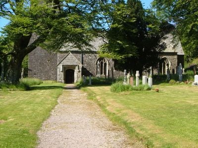
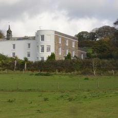
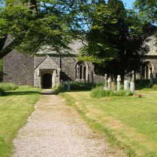
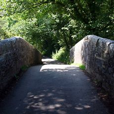
Harford, hamlet and civil parish in South Hams, Devon, England

La comunità dei viaggiatori curiosi

AroundUs riunisce migliaia di luoghi selezionati, consigli locali e gemme nascoste, arricchiti ogni giorno da oltre 60,000 contributori in tutto il mondo.

Inizia a esplorare
Posizione
Coordinate GPS
50.41889,-3.91793
Ultimo aggiornamento
12 marzo 2025 alle 04:38
Intorno a questo luogo
Stowford House
Regno Unito

Stowford House

2.5 km
Church of St Petroc
Regno Unito

Church of St Petroc

47 m
Ivybridge Viaduct including adjacent piers of earlier viaduct
Regno Unito

Ivybridge Viaduct including adjacent piers of earlier viaduct

2.5 km
Harford Bridge
Regno Unito

Harford Bridge

237 m
Stone row, cairn and enclosures near Hook Lane, Erme Valley
Regno Unito

Stone row, cairn and enclosures near Hook Lane, Erme Valley

5.9 km
Cross In Church Yard Approximately 50 Metres South South West Of Church Of St Petroc
Regno Unito

Cross In Church Yard Approximately 50 Metres South South West Of Church Of St Petroc

32 m
Blowing house at junction of Hook Lake and River Erme
Regno Unito

Blowing house at junction of Hook Lake and River Erme

5.7 km
Unenclosed stone hut circle settlement west of Butter Brook Reservoir
Regno Unito

Unenclosed stone hut circle settlement west of Butter Brook Reservoir

615 m
Cairn south-east of Lower Piles
Regno Unito

Cairn south-east of Lower Piles

1.1 km
Hall Farm House
Regno Unito

Hall Farm House

821 m
Cairn near the summit of Western Beacon
Regno Unito

Cairn near the summit of Western Beacon

2.3 km
One of a group of four cairns on Butterdon Hill
Regno Unito

One of a group of four cairns on Butterdon Hill

1.8 km
Cist and retaining kerb south-east of Lower Piles
Regno Unito

Cist and retaining kerb south-east of Lower Piles

1.1 km
Stone alignment and cairns on Stalldown
Regno Unito

Stone alignment and cairns on Stalldown

3 km
Multiple stone alignment and associated cairns west of Glasscombe Upper Plantation
Regno Unito

Multiple stone alignment and associated cairns west of Glasscombe Upper Plantation

3.3 km
Cairn north-east of Harrowthorn Plantation
Regno Unito

Cairn north-east of Harrowthorn Plantation

3.1 km
Lukesland
Regno Unito

Lukesland

1.5 km
Enclosure and hut circles at Piles Corner
Regno Unito

Enclosure and hut circles at Piles Corner

2.8 km
Western White Barrow
Regno Unito

Western White Barrow

6.2 km
Hut circles in Erme Pound E of River Erme
Regno Unito

Hut circles in Erme Pound E of River Erme

6.2 km
Spurrell's Cross
Regno Unito

Spurrell's Cross

2.1 km
Blowing house N of Dry Lake
Regno Unito

Blowing house N of Dry Lake

4 km
One of three cairns on Three Barrows, Ugborough Moor
Regno Unito

One of three cairns on Three Barrows, Ugborough Moor

3.5 km
Cist east of Hangershell Rock
Regno Unito

Cist east of Hangershell Rock

1.9 km
Cairn to the east of Hangershell Rock
Regno Unito

Cairn to the east of Hangershell Rock

1.8 km
Cairn on Sharp Tor
Regno Unito

Cairn on Sharp Tor

2.6 km
Cairn to the west of Tristis Rock, Burford Down
Regno Unito

Cairn to the west of Tristis Rock, Burford Down

729 m
Hillson's House cairn, Stalldown
Regno Unito

Hillson's House cairn, Stalldown

2.9 km
Mostra la mappa completa
Recensioni
Condividi la tua esperienza

Nessuna recensione

Discussioni
Avvia una discussione...

Nessuna discussione

« Harford - hamlet and civil parish in South Hams, Devon, England » è fornito da Around Us (it.aroundus.com). Le immagini e i testi sono tratti dal progetto Wikimedia con licenza Creative Commons. È possibile copiare, distribuire e modificare copie di questa pagina, alle condizioni stabilite dalla licenza, a condizione che questa nota sia chiaramente visibile.

Scopri tesori nascosti ad ogni viaggio!

Da piccoli caffè caratteristici a panorami nascosti, fuggi dalla folla e scova i posti che fanno davvero per te. La nostra app ti semplifica tutto: ricerca vocale, filtri furbi, percorsi ottimizzati e dritte autentiche da viaggiatori di tutto il mondo. Scaricala subito per vivere l'avventura sul tuo smartphone!

Around Us App Screenshot

Un nuovo approccio alla scoperta turistica

Le Figaro

Tutti i luoghi che meritano di essere esplorati

France Info

Un’escursione su misura in pochi clic

20 Minutes

Around Us
Guida di viaggio e mappe
Scarica

Invia al tuo telefono

QR Code
1

Apri l'app fotocamera sul tuo cellulare.

2

Inquadra il codice QR con la fotocamera. Apparirà una notifica.

3

Tocca la notifica per aprire il link.