Stowford House

Accedi al tuo account

AroundUs è una mappa collaborativa di luoghi interessanti, costruita da esploratori curiosi come te. Cresce con ogni recensione, storia e foto che condividi.
Accedi per salvare i tuoi posti preferiti, contribuire con nuovi luoghi e creare percorsi personalizzati.
Continua con Google
Continua con Apple
Continua con X
Continua con Facebook
Continua con email
Continuando, accetti i nostri Termini e Condizioni e la nostra Informativa sulla Privacy
Creare un account
Aggiungi alla collezione
Mappa
Suggerisci una modifica
Condividere

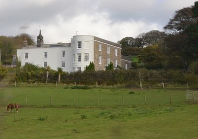
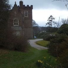
Stowford House, Residenza signorile inglese a Harford, Gran Bretagna.

Stowford House è una residenza di campagna costruita in pietra con una pianta a forma di H, dotata di tetti in ardesia e più camini esterni. Le finestre presentano cornici di pietra scolpita caratteristiche del design originale dell'epoca.

La casa è stata costruita nel 16° secolo e ha subito significativi restauri durante il 18° secolo quando sono stati apportati importanti cambiamenti alla sua struttura. Ha ricevuto lo status di protezione ufficiale nel 1952 come edificio classificato di Grado II.

La casa è legata a personaggi storici importanti che vi nacquero e ricoprirono incarichi significativi a livello nazionale. Questo collegamento conferisce all'edificio un significato che va oltre il suo ruolo di residenza.

L'edificio è stato diviso in tre unità residenziali separate, riflettendo il suo status attuale come residenza privata. I visitatori dovrebbero essere consapevoli che si tratta di proprietà privata e può essere vista solo dall'esterno.

Il piano superiore contiene una stanza con boiserie in legno del 18° secolo che conserva un notevole caminetto in pietra del 16° secolo. Questa stratificazione dei periodi rivela come la casa combina diverse epoche in uno spazio unico.

Posizione: Harford

Coordinate GPS: 50.39690,-3.91361

Ultimo aggiornamento: 14 dicembre 2025 alle 18:04

Foto
Intorno a questo luogo
Church of St Petroc
Regno Unito

Church of St Petroc

2.5 km
Curzon Cinema at the Watermark
Regno Unito

Curzon Cinema at the Watermark

917 m
Lower Keaton Bridge
Regno Unito

Lower Keaton Bridge

2.5 km
Ivybridge Viaduct including adjacent piers of earlier viaduct
Regno Unito

Ivybridge Viaduct including adjacent piers of earlier viaduct

458 m
The Bridge
Regno Unito

The Bridge

781 m
Methodist Church Including Boundary Wall To North And West
Regno Unito

Methodist Church Including Boundary Wall To North And West

1.2 km
Harford Bridge
Regno Unito

Harford Bridge

2.6 km
Bittaford Viaduct
Regno Unito

Bittaford Viaduct

2.5 km
Cross In Church Yard Approximately 50 Metres South South West Of Church Of St Petroc
Regno Unito

Cross In Church Yard Approximately 50 Metres South South West Of Church Of St Petroc

2.5 km
Penquit Manor House
Regno Unito

Penquit Manor House

2.9 km
Unenclosed stone hut circle settlement west of Butter Brook Reservoir
Regno Unito

Unenclosed stone hut circle settlement west of Butter Brook Reservoir

2.4 km
Stowford Paper Mills
Regno Unito

Stowford Paper Mills

621 m
Cairn near the summit of Western Beacon
Regno Unito

Cairn near the summit of Western Beacon

1.6 km
Chambered cairn in Cuckoo Ball newtake
Regno Unito

Chambered cairn in Cuckoo Ball newtake

2.2 km
Hall Farm House
Regno Unito

Hall Farm House

2.9 km
Cist east of Hangershell Rock
Regno Unito

Cist east of Hangershell Rock

2.9 km
Milestone Immediately North East Of Torr Hill (House)
Regno Unito

Milestone Immediately North East Of Torr Hill (House)

662 m
Barn Approximately 10 Metres West Of Penquit Manor House
Regno Unito

Barn Approximately 10 Metres West Of Penquit Manor House

2.9 km
Ludbrook Mill And House
Regno Unito

Ludbrook Mill And House

3.2 km
One of a group of four cairns on Butterdon Hill
Regno Unito

One of a group of four cairns on Butterdon Hill

2.2 km
Lukesland
Regno Unito

Lukesland

994 m
Caton House
Regno Unito

Caton House

2.4 km
Two cairns on the south side of Ugborough Beacon
Regno Unito

Two cairns on the south side of Ugborough Beacon

3.2 km
Cairn to the east of Hangershell Rock
Regno Unito

Cairn to the east of Hangershell Rock

2.9 km
Guidestone, Cross In Hand, Exeter Road, turn to Rugby Club
Regno Unito

Guidestone, Cross In Hand, Exeter Road, turn to Rugby Club

1 km
Cairn to the west of Tristis Rock, Burford Down
Regno Unito

Cairn to the west of Tristis Rock, Burford Down

3.2 km
Milestone, Ugborough Road, Bittaford & Little Bittaford just down from Meadows View
Regno Unito

Milestone, Ugborough Road, Bittaford & Little Bittaford just down from Meadows View

2.9 km
Milepost, Bittaford, E end of village by car sales
Regno Unito

Milepost, Bittaford, E end of village by car sales

2.8 km
Mostra la mappa completa
Recensioni

Ha visitato questo luogo? Tocchi le stelle per valutarlo e condividere la Sua esperienza o foto con la community! Provalo ora! Puoi annullarlo in qualsiasi momento.

« Stowford House - Residenza signorile inglese a Harford, Gran Bretagna » è fornito da Around Us (it.aroundus.com). Le immagini e i testi sono tratti dal progetto Wikimedia con licenza Creative Commons. È possibile copiare, distribuire e modificare copie di questa pagina, alle condizioni stabilite dalla licenza, a condizione che questa nota sia chiaramente visibile.

Scopri tesori nascosti ad ogni viaggio!

Da piccoli caffè caratteristici a panorami nascosti, fuggi dalla folla e scova i posti che fanno davvero per te. La nostra app ti semplifica tutto: ricerca vocale, filtri furbi, percorsi ottimizzati e dritte autentiche da viaggiatori di tutto il mondo. Scaricala subito per vivere l'avventura sul tuo smartphone!

Around Us App Screenshot

Un nuovo approccio alla scoperta turistica

Le Figaro

Tutti i luoghi che meritano di essere esplorati

France Info

Un’escursione su misura in pochi clic

20 Minutes