City Road Lock

Accedi al tuo account

AroundUs è una mappa collaborativa di luoghi interessanti, costruita da esploratori curiosi come te. Cresce con ogni recensione, storia e foto che condividi.
Accedi per salvare i tuoi posti preferiti, contribuire con nuovi luoghi e creare percorsi personalizzati.
Continua con Google
Continua con Apple
Continua con X
Continua con Facebook
Continua con email
Continuando, accetti i nostri Termini e Condizioni e la nostra Informativa sulla Privacy
Creare un account

City Road Lock

Aggiungi alla collezione
Mappa
Suggerisci una modifica
Condividere

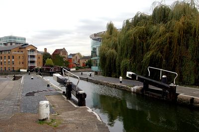
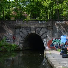
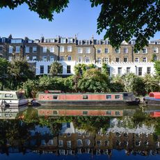
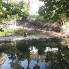
City Road Lock, Chiusa a Islington, Inghilterra

City Road Lock è una coppia di chiuse sul canale Regent a Islington che gestisce i livelli dell'acqua e sposta le imbarcazioni tra il tunnel di Islington e il bacino di City Road. La struttura consente il funzionamento coordinato delle diverse sezioni del canale.

La chiusa fu costruita nel 1820 come parte del progetto del canale Regent che collegava Paddington a Limehouse e supportava il trasporto commerciale a Londra. Era un componente fondamentale progettato per gestire le diverse altezze dell'acqua lungo l'intera via navigabile.

L'area della chiusa attrae persone che amano osservare i barcaioli e i residenti locali che la attraversano regolarmente. Rimane uno spazio dove la funzione attiva del canale è visibile a tutti.

La vista migliore si ottiene dai lati o da punti elevati dove si possono osservare le barche muoversi attraverso le chiuse. La stazione della metropolitana Angel è a distanza a piedi dall'ingresso del tunnel, rendendo l'accesso semplice.

La camera meridionale è stata convertita in uno sfioratore negli anni ottanta per prevenire le inondazioni causate da manovre errate delle paratia durante il passaggio delle imbarcazioni. Questo adattamento mostra come le strutture più vecchie devono evolversi per affrontare le sfide moderne.

Posizione: London Borough of Islington

Coordinate GPS: 51.53270,-0.09892

Ultimo aggiornamento: 14 dicembre 2025 alle 14:05

Foto
Intorno a questo luogo
Lexicon Tower
Regno Unito

Lexicon Tower

329 m
Island Queen
Regno Unito

Island Queen

65 m
Packington Estate
Regno Unito

Packington Estate

350 m
Church of Saint Peter, Islington
Regno Unito

Church of Saint Peter, Islington

273 m
Church of St John
Regno Unito

Church of St John

340 m
Roman Catholic Church of Our Lady of Czestochowa and St Casimir
Regno Unito

Roman Catholic Church of Our Lady of Czestochowa and St Casimir

204 m
The Trafalgar Public House And Attached Railings
Regno Unito

The Trafalgar Public House And Attached Railings

169 m
Number 23 And Attached Railings
Regno Unito

Number 23 And Attached Railings

139 m
East Entrance To The Islington Tunnel Of The Regent's Canal, And Flanking Walls
Regno Unito

East Entrance To The Islington Tunnel Of The Regent's Canal, And Flanking Walls

265 m
56 And 57, Colebrooke Row
Regno Unito

56 And 57, Colebrooke Row

360 m
Numbers 44-53 (Consecutive) And Attached Railings
Regno Unito

Numbers 44-53 (Consecutive) And Attached Railings

331 m
Numbers 28-33 (Consecutive) And Attached Railings
Regno Unito

Numbers 28-33 (Consecutive) And Attached Railings

131 m
54, Colebrooke Row
Regno Unito

54, Colebrooke Row

350 m
16, Wharf Road N1
Regno Unito

16, Wharf Road N1

356 m
133, Shepherdess Walk N16
Regno Unito

133, Shepherdess Walk N16

353 m
Numbers 46, 47, 48 And 49 And Attached Railings
Regno Unito

Numbers 46, 47, 48 And 49 And Attached Railings

333 m
Numbers 1 To 6, 8 To 24A (Consecutive) And Attached Railings
Regno Unito

Numbers 1 To 6, 8 To 24A (Consecutive) And Attached Railings

150 m
Numbers 34-39 (Consecutive) And Attached Railings
Regno Unito

Numbers 34-39 (Consecutive) And Attached Railings

326 m
Numbers 12 To 54 (Even) And Attached Railings
Regno Unito

Numbers 12 To 54 (Even) And Attached Railings

181 m
Numbers 1B To 16 (Consecutive) And Attached Railings
Regno Unito

Numbers 1B To 16 (Consecutive) And Attached Railings

172 m
Railings Along South Side Of Regent's Canal Cutting, And To Colebrooke Row
Regno Unito

Railings Along South Side Of Regent's Canal Cutting, And To Colebrooke Row

279 m
Number 1-20 (Consecutive) And Attached Railings
Regno Unito

Number 1-20 (Consecutive) And Attached Railings

111 m
Number 40-45 (Consecutive) And Attached Railings
Regno Unito

Number 40-45 (Consecutive) And Attached Railings

334 m
55, Colebrooke Row
Regno Unito

55, Colebrooke Row

356 m
Numbers 7 To 9, 13 To 53 (Odd) And Attached Railings
Regno Unito

Numbers 7 To 9, 13 To 53 (Odd) And Attached Railings

182 m
Numbers 383-387 (Odd) And Attached Railings
Regno Unito

Numbers 383-387 (Odd) And Attached Railings

362 m
Numbers 19-25 (Odd) And Attached Railings
Regno Unito

Numbers 19-25 (Odd) And Attached Railings

366 m
Numbers 17 To 20 (Consecutive) And Attached Railings
Regno Unito

Numbers 17 To 20 (Consecutive) And Attached Railings

163 m
Mostra la mappa completa
Recensioni

Ha visitato questo luogo? Tocchi le stelle per valutarlo e condividere la Sua esperienza o foto con la community! Provalo ora! Puoi annullarlo in qualsiasi momento.

« City Road Lock - Chiusa a Islington, Inghilterra » è fornito da Around Us (it.aroundus.com). Le immagini e i testi sono tratti dal progetto Wikimedia con licenza Creative Commons. È possibile copiare, distribuire e modificare copie di questa pagina, alle condizioni stabilite dalla licenza, a condizione che questa nota sia chiaramente visibile.

Scopri tesori nascosti ad ogni viaggio!

Da piccoli caffè caratteristici a panorami nascosti, fuggi dalla folla e scova i posti che fanno davvero per te. La nostra app ti semplifica tutto: ricerca vocale, filtri furbi, percorsi ottimizzati e dritte autentiche da viaggiatori di tutto il mondo. Scaricala subito per vivere l'avventura sul tuo smartphone!

Around Us App Screenshot

Un nuovo approccio alla scoperta turistica

Le Figaro

Tutti i luoghi che meritano di essere esplorati

France Info

Un’escursione su misura in pochi clic

20 Minutes