Cumberland Basin

Accedi al tuo account

AroundUs è una mappa collaborativa di luoghi interessanti, costruita da esploratori curiosi come te. Cresce con ogni recensione, storia e foto che condividi.
Accedi per salvare i tuoi posti preferiti, contribuire con nuovi luoghi e creare percorsi personalizzati.
Continua con Google
Continua con Apple
Continua con X
Continua con Facebook
Continua con email
Continuando, accetti i nostri Termini e Condizioni e la nostra Informativa sulla Privacy
Creare un account

Cumberland Basin

Aggiungi alla collezione
Mappa
Suggerisci una modifica
Condividere

Cumberland Basin, Bacino del canale vicino alla stazione di Euston, Londra, Inghilterra

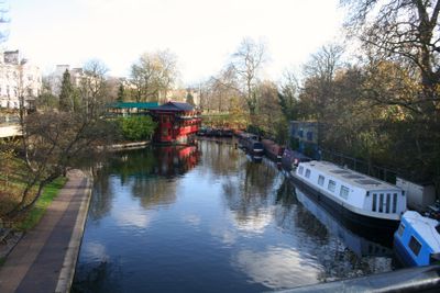
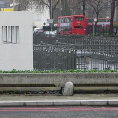
Il bacino di Cumberland è un antico bacino di canale vicino alla stazione di Euston che era parte della rete del Canale Regent. Era collegato alla rete principale delle vie navigabili tramite un braccio di canale lungo circa un chilometro e fungeva da importante punto di carico per le merci.

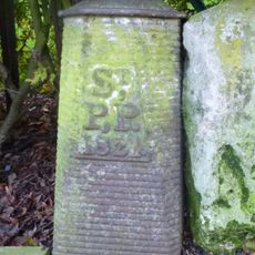
Il bacino fu scavato nel 1813 per fornire accesso ai trasporti al mercato di Cumberland e alla New Road. Rimase operativo fino al 1942, quando fu definitivamente chiuso.

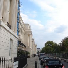
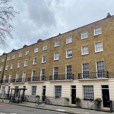
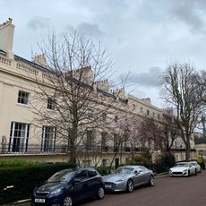
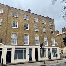
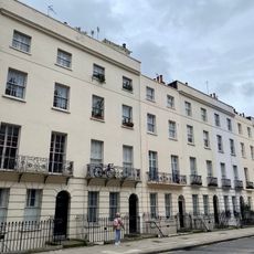
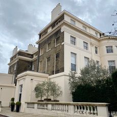
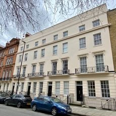
L'area del bacino si trasformò dopo la Prima Guerra Mondiale quando Crown Estate sviluppò progetti abitativi per i veterani.

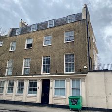
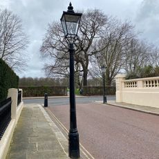
Il luogo è oggi un'area residenziale facilmente raggiungibile dalla stazione di Euston. Passeggiare nel quartiere rivela ponti e strade conservati che seguono il percorso dell'antica via navigabile.

Durante la Seconda Guerra Mondiale, l'acqua rimasta nel vecchio bacino fu utilizzata per alimentare le pompe che proteggevano gli edifici del West End di Londra durante i bombardamenti. Questo riutilizzo pratico della via navigabile dismessa dimostrava come le vecchie infrastrutture potessero ancora servire la città in tempi di necessità.

Coordinate GPS: 51.53020,-0.14250

Ultimo aggiornamento: 14 dicembre 2025 alle 15:25

Foto
Intorno a questo luogo
Carreras Cigarette Factory
Regno Unito

Carreras Cigarette Factory

412 m
Cumberland Terrace
Regno Unito

Cumberland Terrace

350 m
Chester Terrace
Regno Unito

Chester Terrace

241 m
St George's Cathedral
Regno Unito

St George's Cathedral

135 m
Cambridge Terrace
Regno Unito

Cambridge Terrace

377 m
Prince of Wales, Euston
Regno Unito

Prince of Wales, Euston

342 m
Camden Green Fair
Regno Unito

Camden Green Fair

358 m
Church of St Mary Magdalene
Regno Unito

Church of St Mary Magdalene

468 m
Carreras Cigarette Factory cat statues
Regno Unito

Carreras Cigarette Factory cat statues

412 m
Monument To The Christie Family In St James Gardens
Regno Unito

Monument To The Christie Family In St James Gardens

395 m
Animal Drinking Trough Opposite Regents Park Barracks
Regno Unito

Animal Drinking Trough Opposite Regents Park Barracks

303 m
Obelisk To Baron Southampton In South West Corner Of St James Gardens
Regno Unito

Obelisk To Baron Southampton In South West Corner Of St James Gardens

392 m
Prince George Of Cumberland Public House
Regno Unito

Prince George Of Cumberland Public House

215 m
Railings To Garden Forecourt Of Numbers 1-12
Regno Unito

Railings To Garden Forecourt Of Numbers 1-12

196 m
Numbers 63-77 And Attached Railings
Regno Unito

Numbers 63-77 And Attached Railings

352 m
Pair Of Stone Piers With Lamp Standards To West End Of Mornington Street Railway Bridge
Regno Unito

Pair Of Stone Piers With Lamp Standards To West End Of Mornington Street Railway Bridge

469 m
Three lamp posts and two bollards
Regno Unito

Three lamp posts and two bollards

218 m
Four Boundary Markers On North And South Sides Of Road
Regno Unito

Four Boundary Markers On North And South Sides Of Road

419 m
Numbers 1-12 And Attached Railings
Regno Unito

Numbers 1-12 And Attached Railings

188 m
Numbers 4 (the Pastors House) And 5 (st Katherines Hall) And Attached Screen Walls
Regno Unito

Numbers 4 (the Pastors House) And 5 (st Katherines Hall) And Attached Screen Walls

485 m
79-85, Albany Street
Regno Unito

79-85, Albany Street

324 m
Numbers 36-48 And Attached Railings
Regno Unito

Numbers 36-48 And Attached Railings

472 m
Animal Drinking Trough At Southern Junction With Hampstead Road
Regno Unito

Animal Drinking Trough At Southern Junction With Hampstead Road

333 m
Numbers 1-4 And Attached Balustrades And Railings
Regno Unito

Numbers 1-4 And Attached Balustrades And Railings

228 m
St Mary Magdalene's Church War Memorial
Regno Unito

St Mary Magdalene's Church War Memorial

472 m
Railings To Forecourt Garden Of Numbers 1-10
Regno Unito

Railings To Forecourt Garden Of Numbers 1-10

396 m
Two Lamp Posts
Regno Unito

Two Lamp Posts

227 m
Numbers 55-61 And Attached Railings
Regno Unito

Numbers 55-61 And Attached Railings

386 m
Mostra la mappa completa
Recensioni

Ha visitato questo luogo? Tocchi le stelle per valutarlo e condividere la Sua esperienza o foto con la community! Provalo ora! Puoi annullarlo in qualsiasi momento.

« Cumberland Basin - Bacino del canale vicino alla stazione di Euston, Londra, Inghilterra » è fornito da Around Us (it.aroundus.com). Le immagini e i testi sono tratti dal progetto Wikimedia con licenza Creative Commons. È possibile copiare, distribuire e modificare copie di questa pagina, alle condizioni stabilite dalla licenza, a condizione che questa nota sia chiaramente visibile.

Scopri tesori nascosti ad ogni viaggio!

Da piccoli caffè caratteristici a panorami nascosti, fuggi dalla folla e scova i posti che fanno davvero per te. La nostra app ti semplifica tutto: ricerca vocale, filtri furbi, percorsi ottimizzati e dritte autentiche da viaggiatori di tutto il mondo. Scaricala subito per vivere l'avventura sul tuo smartphone!

Around Us App Screenshot

Un nuovo approccio alla scoperta turistica

Le Figaro

Tutti i luoghi che meritano di essere esplorati

France Info

Un’escursione su misura in pochi clic

20 Minutes