Milecastle 2

Accedi al tuo account

AroundUs è una mappa collaborativa di luoghi interessanti, costruita da esploratori curiosi come te. Cresce con ogni recensione, storia e foto che condividi.
Accedi per salvare i tuoi posti preferiti, contribuire con nuovi luoghi e creare percorsi personalizzati.
Continuando, accetti i nostri Termini e Condizioni e la nostra Informativa sulla Privacy
Aggiungi alla collezione
Mappa
Suggerisci una modifica
Condividere

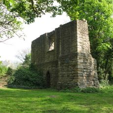
Milecastle 2, Posto di controllo romano sul Vallo di Adriano, Tyne and Wear, Inghilterra.

Le fondamenta in pietra del Fortino 2 si ergono lungo il Vallo di Adriano, con alloggi per la guarnigione e zone di stoccaggio.

Costruito nel 122 durante il regno dell'imperatore Adriano, questo forte controllava i movimenti tra il territorio romano e le terre tribali.

Il fortino fungeva da punto d'incontro tra soldati romani e mercanti locali, facilitando gli scambi commerciali e culturali.
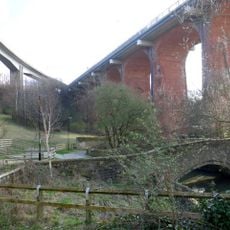
La posizione strategica del Fortino 2 consentiva alle forze romane di controllare il passaggio attraverso il muro e sorvegliare i territori.

Gli scavi archeologici nel Fortino 2 hanno portato alla luce monete romane, frammenti di ceramica e attrezzature militari dell'epoca.

Posizione: Tyne and Wear

Parte di: Hadrian's Wall

Coordinate GPS: 54.97898,-1.56945

Ultimo aggiornamento: 4 marzo 2025 alle 20:13

Intorno a questo luogo
Mostra la mappa completa
Byker Wall
Regno Unito

Byker Wall

703 m
Milecastle 3
Regno Unito

Milecastle 3

1.3 km
Church of St Michael With St Lawrence
Regno Unito

Church of St Michael With St Lawrence

648 m
Church of St Silas
Regno Unito

Church of St Silas

1.1 km
1-52 Raby Gate, 1-55 Shipley Rise, attached walls, seats, fences, pergolas and steps, and Structure Housing District Heating System
Regno Unito

1-52 Raby Gate, 1-55 Shipley Rise, attached walls, seats, fences, pergolas and steps, and Structure Housing District Heating System

686 m
Tom Collins House
Regno Unito

Tom Collins House

1.1 km
1, 2 and 3 Grace Street
Regno Unito

1, 2 and 3 Grace Street

566 m
Swimming Baths
Regno Unito

Swimming Baths

781 m
1-81 Felton Walk,  St Lawrence RC Church and Church Hall, 1-28 Byker Crescent, 1-8 Headlam House, 1-12 Felton House, and attached walls, fences and pergolas
Regno Unito

1-81 Felton Walk, St Lawrence RC Church and Church Hall, 1-28 Byker Crescent, 1-8 Headlam House, 1-12 Felton House, and attached walls, fences and pergolas

483 m
1-89 Gordon Road
Regno Unito

1-89 Gordon Road

889 m
1-75 Dunn Terrace, including Graham House, Wolseley House, The Cabin, YMCA Byker Neighbourhood Youth Project, 1-66 Northumberland Terrace, Salisbury House
Regno Unito

1-75 Dunn Terrace, including Graham House, Wolseley House, The Cabin, YMCA Byker Neighbourhood Youth Project, 1-66 Northumberland Terrace, Salisbury House

1.2 km
Adam of Jesmond's Camera
Regno Unito

Adam of Jesmond's Camera

1.1 km
1-7 Raby Cross
Regno Unito

1-7 Raby Cross

951 m
Byker Neighbourhood Estate Office
Regno Unito

Byker Neighbourhood Estate Office

902 m
East End Library
Regno Unito

East End Library

595 m
1-17 and Attached Fences and Curbs
Regno Unito

1-17 and Attached Fences and Curbs

861 m
1-39 Mount Pleasant House and Attached Walls and Fences
Regno Unito

1-39 Mount Pleasant House and Attached Walls and Fences

590 m
1-17 Kendal House, 1-21 Gordon House, 1-47 Dalton Crescent, 1-58 Shipley Walk, and 1-18 Brinkburn Court with attached garden walls
Regno Unito

1-17 Kendal House, 1-21 Gordon House, 1-47 Dalton Crescent, 1-58 Shipley Walk, and 1-18 Brinkburn Court with attached garden walls

966 m
2-38 Kendal Street with retaining walls
Regno Unito

2-38 Kendal Street with retaining walls

968 m
39-79 Raby Street with attached bin stores and sheds, and walls and fences to rear
Regno Unito

39-79 Raby Street with attached bin stores and sheds, and walls and fences to rear

793 m
1, 2 And 3 And Attached Ramps
Regno Unito

1, 2 And 3 And Attached Ramps

912 m
18-22 With Attached Fences And Garages To The Rear
Regno Unito

18-22 With Attached Fences And Garages To The Rear

578 m
Nos. 1-14, With Attached Archway And Ramp, And Walls And Fences To Rear
Regno Unito

Nos. 1-14, With Attached Archway And Ramp, And Walls And Fences To Rear

736 m
1,3 And 5 And Attached Fences
Regno Unito

1,3 And 5 And Attached Fences

566 m
Nos 1 And 2, St Lawrence Court, With Attached Fences And Seats
Regno Unito

Nos 1 And 2, St Lawrence Court, With Attached Fences And Seats

435 m
No.1 -17, With Kerbs To Front And Attached Fences
Regno Unito

No.1 -17, With Kerbs To Front And Attached Fences

479 m
85-105 Raby Street with attached fences
Regno Unito

85-105 Raby Street with attached fences

866 m
1-11 Winship Terrace with kerbs to front and fences to rear
Regno Unito

1-11 Winship Terrace with kerbs to front and fences to rear

463 m
Mostra la mappa completa

Recensioni

Ha visitato questo luogo? Tocchi le stelle per valutarlo e condividere la Sua esperienza o foto con la community! Provalo ora! Puoi annullarlo in qualsiasi momento.

« Milecastle 2: Posto di controllo romano sul Vallo di Adriano, Tyne and Wear, Inghilterra » è fornito da Around Us (it.aroundus.com). Le immagini e i testi sono tratti dal progetto Wikimedia con licenza Creative Commons. È possibile copiare, distribuire e modificare copie di questa pagina, alle condizioni stabilite dalla licenza, a condizione che questa nota sia chiaramente visibile.

Scopri tesori nascosti ad ogni viaggio!

Da piccoli caffè caratteristici a panorami nascosti, fuggi dalla folla e scova i posti che fanno davvero per te. La nostra app ti semplifica tutto: ricerca vocale, filtri furbi, percorsi ottimizzati e dritte autentiche da viaggiatori di tutto il mondo. Scaricala subito per vivere l'avventura sul tuo smartphone!

Around Us App Screenshot

Un nuovo approccio alla scoperta turistica

Le Figaro

Tutti i luoghi che meritano di essere esplorati

France Info

Un’escursione su misura in pochi clic

20 Minutes