Stockers Lake

Accedi al tuo account

AroundUs è una mappa collaborativa di luoghi interessanti, costruita da esploratori curiosi come te. Cresce con ogni recensione, storia e foto che condividi.
Accedi per salvare i tuoi posti preferiti, contribuire con nuovi luoghi e creare percorsi personalizzati.
Continua con Google
Continua con Apple
Continua con X
Continua con Facebook
Continua con email
Continuando, accetti i nostri Termini e Condizioni e la nostra Informativa sulla Privacy
Creare un account

Stockers Lake

Aggiungi alla collezione
Mappa
Suggerisci una modifica
Condividere

Stockers Lake, Riserva naturale a Rickmansworth, Regno Unito.

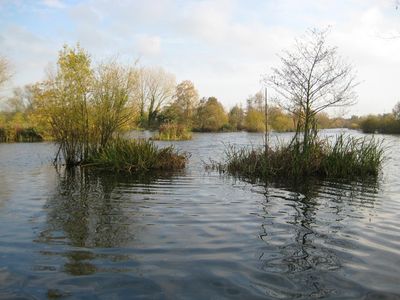
Stockers Lake è una riserva naturale a Rickmansworth con diverse isole formate da creste di ghiaia. Queste isole offrono spazi protetti per uccelli residenti e migratori durante tutto l'anno.

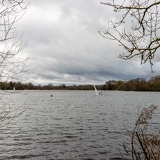
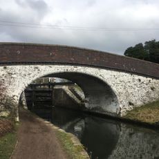
Il lago si è formato negli anni 1920 e 1930 dall'estrazione di ghiaia, il cui materiale è stato utilizzato nella costruzione dello Stadio di Wembley. Questo passato industriale si è trasformato in un importante habitat per la fauna.

I gruppi locali di conservazione gestiscono attivamente il sito e invitano regolarmente i visitatori a partecipare alle attività di monitoraggio della fauna. La comunità svolge un ruolo importante nella protezione di questo habitat per gli uccelli locali e migratori.

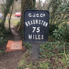
Accedi al sito attraverso sentieri non asfaltati che iniziano dal parcheggio dell'Aquadrome, dove troverai tre capanne di osservazione degli uccelli e un punto di vista per gli aironi. Indossa scarpe appropriate poiché i sentieri possono essere fangosi o irregolari a seconda del tempo.

Il sito ospita la più grande garzaia dello Hertfordshire, con fino a 20 nidi negli alberi sulle isole d'acqua dove nidificano aironi e nitticore. Questa concentrazione di uccelli nidificanti è notevole per la regione.

Coordinate GPS: 51.63000,-0.48800

Ultimo aggiornamento: 14 dicembre 2025 alle 18:44

Foto
Intorno a questo luogo
Rickmansworth Aquadrome
Regno Unito

Rickmansworth Aquadrome

742 m
Church of St Peter
Regno Unito

Church of St Peter

828 m
Church of St Mary, Rickmansworth
Regno Unito

Church of St Mary, Rickmansworth

1.6 km
25 and 27, Church Street
Regno Unito

25 and 27, Church Street

1.6 km
99, Church Street
Regno Unito

99, Church Street

1.6 km
29 and 31, Church Street
Regno Unito

29 and 31, Church Street

1.6 km
The Fox And Hounds Public House
Regno Unito

The Fox And Hounds Public House

1.4 km
Wilson Monument Immediately North Of Chancel Of Church Of St Mary
Regno Unito

Wilson Monument Immediately North Of Chancel Of Church Of St Mary

1.6 km
The Feathers Public House
Regno Unito

The Feathers Public House

1.6 km
London Coal Duty Marker On Towing Path About 10 Metres South East Of Stocker's House
Regno Unito

London Coal Duty Marker On Towing Path About 10 Metres South East Of Stocker's House

446 m
London Coal Duty Marker On Footpath On County Boundary About 880 Metres North West Of Wellington Grove (Not Listed)
Regno Unito

London Coal Duty Marker On Footpath On County Boundary About 880 Metres North West Of Wellington Grove (Not Listed)

761 m
Mile Post On Towing Path About 600 Metres North East Of Stocker's Lock
Regno Unito

Mile Post On Towing Path About 600 Metres North East Of Stocker's Lock

1 km
London Coal Duty Marker On County Boundary On Towing Path About 620 Metres South West Of Stocker's Lock (Q.V.)
Regno Unito

London Coal Duty Marker On County Boundary On Towing Path About 620 Metres South West Of Stocker's Lock (Q.V.)

232 m
Bridge Number 175 At Stocker's Lock
Regno Unito

Bridge Number 175 At Stocker's Lock

455 m
The Priory
Regno Unito

The Priory

1.6 km
The Chequers Restaurant
Regno Unito

The Chequers Restaurant

1.6 km
The Old Vicarage
Regno Unito

The Old Vicarage

1.6 km
Stockers Lock House
Regno Unito

Stockers Lock House

462 m
Stockers House
Regno Unito

Stockers House

435 m
The Whip And Collar Public House
Regno Unito

The Whip And Collar Public House

557 m
Pair Of Chest Tombs With Fluted Corner Piers About 10 Metres North Of Church Of St Mary
Regno Unito

Pair Of Chest Tombs With Fluted Corner Piers About 10 Metres North Of Church Of St Mary

1.6 km
Barn And Cart Shed About 35 Metres North North West Of Stocker's Farm House
Regno Unito

Barn And Cart Shed About 35 Metres North North West Of Stocker's Farm House

453 m
72, 72A And 72B, High Street
Regno Unito

72, 72A And 72B, High Street

1.6 km
21 And 25, Harefield Road
Regno Unito

21 And 25, Harefield Road

1.4 km
Barn About 25 Metres North West Of Stocker's Farm House
Regno Unito

Barn About 25 Metres North West Of Stocker's Farm House

443 m
142 And 144, High Street
Regno Unito

142 And 144, High Street

1.5 km
The Bury
Regno Unito

The Bury

1.5 km
Stockers Lock Number 82
Regno Unito

Stockers Lock Number 82

470 m
Mostra la mappa completa
Recensioni

Ha visitato questo luogo? Tocchi le stelle per valutarlo e condividere la Sua esperienza o foto con la community! Provalo ora! Puoi annullarlo in qualsiasi momento.

« Stockers Lake - Riserva naturale a Rickmansworth, Regno Unito » è fornito da Around Us (it.aroundus.com). Le immagini e i testi sono tratti dal progetto Wikimedia con licenza Creative Commons. È possibile copiare, distribuire e modificare copie di questa pagina, alle condizioni stabilite dalla licenza, a condizione che questa nota sia chiaramente visibile.

Scopri tesori nascosti ad ogni viaggio!

Da piccoli caffè caratteristici a panorami nascosti, fuggi dalla folla e scova i posti che fanno davvero per te. La nostra app ti semplifica tutto: ricerca vocale, filtri furbi, percorsi ottimizzati e dritte autentiche da viaggiatori di tutto il mondo. Scaricala subito per vivere l'avventura sul tuo smartphone!

Around Us App Screenshot

Un nuovo approccio alla scoperta turistica

Le Figaro

Tutti i luoghi che meritano di essere esplorati

France Info

Un’escursione su misura in pochi clic

20 Minutes