Wincobank

Accedi al tuo account

AroundUs è una mappa collaborativa di luoghi interessanti, costruita da esploratori curiosi come te. Cresce con ogni recensione, storia e foto che condividi.
Accedi per salvare i tuoi posti preferiti, contribuire con nuovi luoghi e creare percorsi personalizzati.
Continua con Google
Continua con Apple
Continua con X
Continua con Facebook
Continua con email
Continuando, accetti i nostri Termini e Condizioni e la nostra Informativa sulla Privacy
Creare un account
Aggiungi alla collezione
Mappa
Suggerisci una modifica
Condividere

Wincobank, Forte di contorno dell'Età del Ferro a Sheffield, Inghilterra.

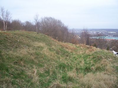
Wincobank è un forte di contorno di forma ovale situato su una collina di arenaria vicino a Sheffield. La fortificazione presenta argini e fossati ancora visibili che dominano la valle del fiume Don.

Questa fortificazione fu costruita intorno al 500 a.C. dalla tribù celtica dei Briganti. La datazione al radiocarbonio ha confermato questa cronologia antica dell'insediamento.

Il sito mostra antiche tecniche costruttive visibili nelle sue strutture in terra che gli archeologi continuano a studiare. Questi resti aiutano a capire come la gente creò le difese migliaia di anni fa.

L'ingresso principale si trova sul lato sud-est ed è accessibile dall'area circostante. I resti di terra rimangono ben definiti, permettendo di camminare attorno al forte e esaminarne il layout.

I materiali dei bastioni mostrano segni di vetrificazione dovuti all'esposizione al calore estremo. Questo fenomeno insolito suggerisce che il forte abbia subito un incendio intenso in qualche momento.

Posizione: South Yorkshire

Posizione: Sheffield

Parte di: Wincobank slight univallate hillfort and World War II anti-aircraft gun and searchlight emplacement

Coordinate GPS: 53.41437,-1.43305

Ultimo aggiornamento: 10 dicembre 2025 alle 21:08

Foto
Intorno a questo luogo
Meadowhall Centre
Regno Unito

Meadowhall Centre

1.5 km
Tinsley Viaduct
Regno Unito

Tinsley Viaduct

1.8 km
Valley Centertainment
Regno Unito

Valley Centertainment

1.9 km
Man of Steel
Regno Unito

Man of Steel

2.1 km
Blackburn Meadows
Regno Unito

Blackburn Meadows

2.2 km
Carbrook Hall
Regno Unito

Carbrook Hall

1.5 km
Attercliffe Chapel
Regno Unito

Attercliffe Chapel

1.7 km
Regno Unito

Firth Park

906 m
St Thomas, Brightside
Regno Unito

St Thomas, Brightside

859 m
Church of St James and St Christopher
Regno Unito

Church of St James and St Christopher

1.7 km
Church of St Thomas
Regno Unito

Church of St Thomas

1.2 km
Church of St Cuthbert
Regno Unito

Church of St Cuthbert

1.4 km
Trinity Fir Vale Methodist Church
Regno Unito

Trinity Fir Vale Methodist Church

1.3 km
War Memorial 400 Metres North East of Chapel at Burngreave Cemetery
Regno Unito

War Memorial 400 Metres North East of Chapel at Burngreave Cemetery

2.2 km
Adelphi Picture Theatre
Regno Unito

Adelphi Picture Theatre

2 km
Grimesthorpe Pump
Regno Unito

Grimesthorpe Pump

903 m
Sheffield City Council Sport And Development Section District Office
Regno Unito

Sheffield City Council Sport And Development Section District Office

770 m
Firth Park Methodist Church, Adjoining Meeting Room And Boundary Wall
Regno Unito

Firth Park Methodist Church, Adjoining Meeting Room And Boundary Wall

1.1 km
18, 20 And 22, Page Hall Road
Regno Unito

18, 20 And 22, Page Hall Road

1.2 km
Sewer Gas Lamp at Junction with Tipton Lane
Regno Unito

Sewer Gas Lamp at Junction with Tipton Lane

593 m
Workshop At Darnall Works Approximately 40 Metres To South East Of Number 20 (Number 20 Not Included)
Regno Unito

Workshop At Darnall Works Approximately 40 Metres To South East Of Number 20 (Number 20 Not Included)

2.5 km
Royal Bank of Scotland
Regno Unito

Royal Bank of Scotland

2.1 km
1-7, Hatfield House Croft
Regno Unito

1-7, Hatfield House Croft

1.6 km
Boundary Walls And Gate Piers To Church Of St Thomas
Regno Unito

Boundary Walls And Gate Piers To Church Of St Thomas

1.2 km
Workshop At Darnall Works Approximately 30 Metres South West Of Number 20 (Number 20 Not Included)
Regno Unito

Workshop At Darnall Works Approximately 30 Metres South West Of Number 20 (Number 20 Not Included)

2.5 km
Sewer Gas Lamp at Junction with Monckton Road
Regno Unito

Sewer Gas Lamp at Junction with Monckton Road

462 m
Enchanted Chairs
Regno Unito

Enchanted Chairs

386 m
Spider's Web Sculpture
Regno Unito

Spider's Web Sculpture

2.3 km
Mostra la mappa completa
Recensioni

Ha visitato questo luogo? Tocchi le stelle per valutarlo e condividere la Sua esperienza o foto con la community! Provalo ora! Puoi annullarlo in qualsiasi momento.

« Wincobank - Forte di contorno dell'Età del Ferro a Sheffield, Inghilterra » è fornito da Around Us (it.aroundus.com). Le immagini e i testi sono tratti dal progetto Wikimedia con licenza Creative Commons. È possibile copiare, distribuire e modificare copie di questa pagina, alle condizioni stabilite dalla licenza, a condizione che questa nota sia chiaramente visibile.

Scopri tesori nascosti ad ogni viaggio!

Da piccoli caffè caratteristici a panorami nascosti, fuggi dalla folla e scova i posti che fanno davvero per te. La nostra app ti semplifica tutto: ricerca vocale, filtri furbi, percorsi ottimizzati e dritte autentiche da viaggiatori di tutto il mondo. Scaricala subito per vivere l'avventura sul tuo smartphone!

Around Us App Screenshot

Un nuovo approccio alla scoperta turistica

Le Figaro

Tutti i luoghi che meritano di essere esplorati

France Info

Un’escursione su misura in pochi clic

20 Minutes