
Square earthwork enclosure 450m north west of Baltic Farm on Morgan's Hill
Square earthwork enclosure 450m north west of Baltic Farm on Morgan's Hill, archaeological site in Wiltshire, UK
Posizione: Bishops Cannings
Coordinate GPS: 51.40240,-1.94383
Ultimo aggiornamento: 7 novembre 2025 alle 04:04
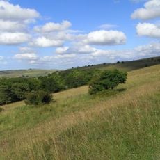
Morgan's Hill
1.2 km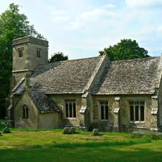
Church of St Mary
1.7 km
Eleven round barrows 1000m north of Baltic Farm forming part of a barrow cemetery, and a probable enclosed Iron Age farmstead on
668 m
Round barrow 1260m NNE of Baltic Farm, 75m south of Roman Road, forming part of a barrow cemetery situated on North Down
1.2 km
Five round barrows 1040m NNE of Baltic Farm forming part of a barrow cemetery on North Down
981 m
Square enclosure 350m north of Wansdyke on Bishop's Cannings Down
1.8 km
Bell barrow forming part of a round barrow cemetery on North Down
1.8 km
Bell barrow forming part of a round barrow cemetery 135m ENE of Baltic Farm
697 m
Linear earthworks forming part of a field system on Bishop's Cannings Down
1.7 km
Bowl barrow 550m north-east of Baltic Farm
1.1 km
Milestone 500 Metres South Of Three Barrows
1.5 km
Cross ridge dyke on Morgan's Hill
853 m
Bowl barrow 150m east of the wireless station on Morgan's Hill
757 m
Bowl barrow 1km north-east of Baltic Farm
1.2 km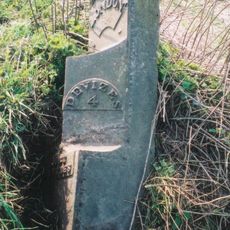
Milestone Approximately 200 Metres South Of The Wansdyke
1 km
Bowl barrow forming part of a round barrow cemetery 120m north of the Devizes to Beckhampton road on North Down
1.9 km
Bowl barrow 1070m NNW of Baltic Farm forming part of a barrow cemetery on North Down
534 m
Bowl barrow 500m west of the wireless station on Morgan's Hill; part of a group of three bowl barrows
1.4 km
Bowl barrow situated 500m SSW of Shepherds' Shore
1.4 km
Bowl barrow at east end of Morgan's Hill
593 m
Bowl barrow 840m north-east of Baltic Farm
1.1 km
Long barrow 650m WSW of Shepherds' Shore
967 m
Group of three bowl barrows 250m north east of Shepherds' Shore
995 m
Bowl barrow 300m east of Furze Knoll
666 m
Pair of bell barrows and a pair of bowl barrows forming part of a barrow cemetery at Baltic Farm
676 m
Bowl barrow 1150m north-east of Baltic Farm
1.4 km
Toghill House
1.8 km
Punto di vista panoramico
910 mRecensioni
Ha visitato questo luogo? Tocchi le stelle per valutarlo e condividere la Sua esperienza o foto con la community! Provalo ora! Puoi annullarlo in qualsiasi momento.
Scopri tesori nascosti ad ogni viaggio!
Da piccoli caffè caratteristici a panorami nascosti, fuggi dalla folla e scova i posti che fanno davvero per te. La nostra app ti semplifica tutto: ricerca vocale, filtri furbi, percorsi ottimizzati e dritte autentiche da viaggiatori di tutto il mondo. Scaricala subito per vivere l'avventura sul tuo smartphone!

Un nuovo approccio alla scoperta turistica❞
— Le Figaro
Tutti i luoghi che meritano di essere esplorati❞
— France Info
Un’escursione su misura in pochi clic❞
— 20 Minutes