
Ebchester Roman station, archaeological site in Ebchester, County Durham, England, UK
Posizione: County Durham
Coordinate GPS: 54.89440,-1.84033
Ultimo aggiornamento: 15 giugno 2024 alle 18:49
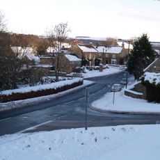
Vindomora
125 m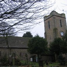
Church of St Ebba
82 m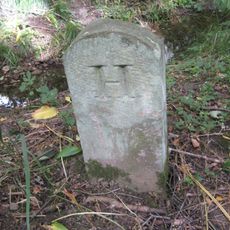
Boundary Stone At Ngr Nz 09705632, On West Side Of Mill Burn
1 km
Demesne Farm Demesne House
101 m
2 Tombs Circa 5 Metres South Of Chancel Of Church Of St Ebba
91 m
K6 Telephone Kiosk In Front Of Chare Top Cottage
146 m
Outbuilding North East Of Demesne House
86 m
Group Of 2 Tombs Circa 5 Metres South Of Vestry Of Church Of St Ebba
91 m
Group Of 5 Tombs Circa 3 Metres South Of Vestry Of Church Of St Ebba
94 m
The Former Rectory
94 m
Beckwith Headstones Circa 10 Metres South Of Vestry Of Church Of At Ebba
96 m
Church House
69 m
Walls In Front Of Demesne Farm And Demesne House
107 m
Ebchester War Memorial
65 m
School House
132 m
Pound behind School House
142 m
Wheldon House
143 m
Leyburn Tombs Circa 7 Metres South Of Nave Of Church Of St Ebba
91 m
Chare Top Cottage
153 m
Burn House
180 m
Jubilee House
194 m
Ebchester Bridge
305 m
Ebchester Old Bridge
305 m
St Mary's Convent
359 m
Prospect House
398 m
Outbuilding To South Of Prospect House
427 m
The Heugh
739 m
Main's Farmhouse
55 mRecensioni
Ha visitato questo luogo? Tocchi le stelle per valutarlo e condividere la Sua esperienza o foto con la community! Provalo ora! Puoi annullarlo in qualsiasi momento.
Scopri tesori nascosti ad ogni viaggio!
Da piccoli caffè caratteristici a panorami nascosti, fuggi dalla folla e scova i posti che fanno davvero per te. La nostra app ti semplifica tutto: ricerca vocale, filtri furbi, percorsi ottimizzati e dritte autentiche da viaggiatori di tutto il mondo. Scaricala subito per vivere l'avventura sul tuo smartphone!

Un nuovo approccio alla scoperta turistica❞
— Le Figaro
Tutti i luoghi che meritano di essere esplorati❞
— France Info
Un’escursione su misura in pochi clic❞
— 20 Minutes