The Pumping Station, Whitacre Waterworks

Accedi al tuo account

AroundUs è una mappa collaborativa di luoghi interessanti, costruita da esploratori curiosi come te. Cresce con ogni recensione, storia e foto che condividi.
Accedi per salvare i tuoi posti preferiti, contribuire con nuovi luoghi e creare percorsi personalizzati.
Continua con Google
Continua con Apple
Continua con X
Continua con Facebook
Continua con email
Continuando, accetti i nostri Termini e Condizioni e la nostra Informativa sulla Privacy
Creare un account

The Pumping Station, Whitacre Waterworks

Aggiungi alla collezione
Mappa
Suggerisci una modifica
Condividere

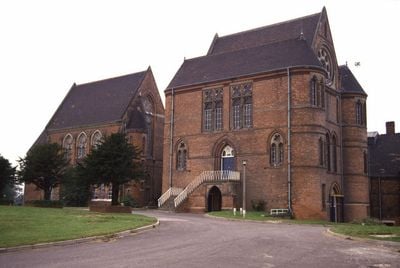
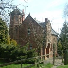
The Pumping Station, Whitacre Waterworks, Stazione di pompaggio vittoriana a Shustoke, Inghilterra

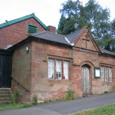
La stazione di pompaggio è un edificio in mattoni rossi con finiture in pietra, finestre gotiche e una sezione centrale con frontone prominente. La struttura presenta torri d'angolo cilindriche e decorazioni in tegole di argilla che trasformano un impianto industriale in un'opera architettonica raffinata.

Costruita nel 1883, la struttura inizialmente forniva acqua a Birmingham e successivamente espanse i suoi servizi a Coventry, Nuneaton e Bedworth. Questo modello di crescita riflette la rapida espansione industriale nei Midlands durante la fine del 1800.

Il nome e le scelte architettoniche riflettono l'importanza dell'acqua pulita per la crescita industriale della regione durante l'era vittoriana. L'edificio mostra l'orgoglio delle comunità nel fornire questo servizio essenziale.

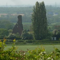
L'edificio è attualmente inaccessibile e si trova abbandonato dietro un moderno impianto di trattamento delle acque. È possibile visualizzare l'architettura esterna dai terreni circostanti, anche se l'accesso interno non è disponibile.

Uno dei motori a travetto James Watt originali che alimentavano questa stazione è ora esposto nel Museo ThinkTank di Birmingham. Questo motore rappresenta la tecnologia a vapore che originariamente alimentava l'intera operazione.

Posizione: Shustoke

Inizio: 1883

Coordinate GPS: 52.51863,-1.68321

Ultimo aggiornamento: 14 dicembre 2025 alle 19:10

Foto
Intorno a questo luogo
Castello di Maxstoke
Regno Unito

Castello di Maxstoke

2.3 km
Blyth Hall
Regno Unito

Blyth Hall

1.3 km
Church of St Peter and St Paul, Coleshill
Regno Unito

Church of St Peter and St Paul, Coleshill

2.6 km
Church of St Nicholas and St Peter ad Vincula, Curdworth
Regno Unito

Church of St Nicholas and St Peter ad Vincula, Curdworth

4.1 km
St Peter and St Paul's Church, Water Orton
Regno Unito

St Peter and St Paul's Church, Water Orton

3.9 km
Church of St Leonard
Regno Unito

Church of St Leonard

3.9 km
Church of St Cuthbert, Shustoke
Regno Unito

Church of St Cuthbert, Shustoke

2.7 km
Church of St Michael and All Angels
Regno Unito

Church of St Michael and All Angels

4.8 km
Church of St Giles
Regno Unito

Church of St Giles

2.2 km
Church of St John the Baptist
Regno Unito

Church of St John the Baptist

1.9 km
The Bulls Head Inn
Regno Unito

The Bulls Head Inn

3.2 km
Remains of Tower and Walls of Monastic Church Approximately 250 Metres South of Priory Farmhouse
Regno Unito

Remains of Tower and Walls of Monastic Church Approximately 250 Metres South of Priory Farmhouse

4.9 km
Blyth Bridge (That Part In Coleshill Civil Parish)
Regno Unito

Blyth Bridge (That Part In Coleshill Civil Parish)

1.5 km
Cole Bridge
Regno Unito

Cole Bridge

2.4 km
The Old Rectory
Regno Unito

The Old Rectory

4.8 km
Water Orton Bridge
Regno Unito

Water Orton Bridge

4.2 km
Coleshill War Memorial, Warwickshire
Regno Unito

Coleshill War Memorial, Warwickshire

2.6 km
Churchyard Cross At Church Of St Leonard
Regno Unito

Churchyard Cross At Church Of St Leonard

3.9 km
Outer Gatehouse and Attached Precinct Walls and Barn 200 Metres North of Priory Farmhouse
Regno Unito

Outer Gatehouse and Attached Precinct Walls and Barn 200 Metres North of Priory Farmhouse

4.7 km
Priory Farmhouse
Regno Unito

Priory Farmhouse

4.8 km
Churchyard cross, St Michael's churchyard
Regno Unito

Churchyard cross, St Michael's churchyard

4.8 km
Precinct Wall, 60 Metres Northwest of Old Rectory
Regno Unito

Precinct Wall, 60 Metres Northwest of Old Rectory

4.7 km
Monwode House Farmhouse
Regno Unito

Monwode House Farmhouse

4.9 km
Blythe Lodge
Regno Unito

Blythe Lodge

1.5 km
Precinct Wall, East of Outer Gatehouse and Bounding Churchyard of St Michael and All Saints on the West
Regno Unito

Precinct Wall, East of Outer Gatehouse and Bounding Churchyard of St Michael and All Saints on the West

4.8 km
Manor House
Regno Unito

Manor House

4.6 km
Village Hall
Regno Unito

Village Hall

3.8 km
Blyth Hall Packhorse Bridge
Regno Unito

Blyth Hall Packhorse Bridge

542 m
Mostra la mappa completa
Recensioni

Ha visitato questo luogo? Tocchi le stelle per valutarlo e condividere la Sua esperienza o foto con la community! Provalo ora! Puoi annullarlo in qualsiasi momento.

« The Pumping Station, Whitacre Waterworks - Stazione di pompaggio vittoriana a Shustoke, Inghilterra » è fornito da Around Us (it.aroundus.com). Le immagini e i testi sono tratti dal progetto Wikimedia con licenza Creative Commons. È possibile copiare, distribuire e modificare copie di questa pagina, alle condizioni stabilite dalla licenza, a condizione che questa nota sia chiaramente visibile.

Scopri tesori nascosti ad ogni viaggio!

Da piccoli caffè caratteristici a panorami nascosti, fuggi dalla folla e scova i posti che fanno davvero per te. La nostra app ti semplifica tutto: ricerca vocale, filtri furbi, percorsi ottimizzati e dritte autentiche da viaggiatori di tutto il mondo. Scaricala subito per vivere l'avventura sul tuo smartphone!

Around Us App Screenshot

Un nuovo approccio alla scoperta turistica

Le Figaro

Tutti i luoghi che meritano di essere esplorati

France Info

Un’escursione su misura in pochi clic

20 Minutes