Oatlands, building in Shermanbury, Horsham, West Sussex, UK
Posizione: Shermanbury
Coordinate GPS: 50.95215,-0.27984
Ultimo aggiornamento: 25 novembre 2023 alle 01:27
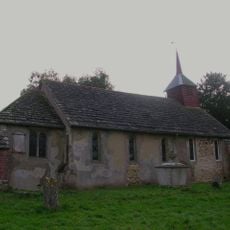
The Parish Church of St Giles, Shermanbury
679 m
Chestham Park
933 m
Granary To North West Of Chestham Park
879 m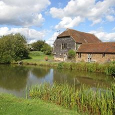
Sakeham Farmhouse
1.6 km
Farmgate House
1.6 km
Moated site at Ewhurst Manor
638 m
Bottings Farmhouse
389 m
Mockbridge House
286 m
The Gateway And Porters Lodge To The North West Of Ewhurst Manor
683 m
Nymans Farmhouse
443 m
Little Betley
1.3 km
Cart Shed And Granary To East Of Brightham's Farmhouse
1.5 km
The Malthouse, Mockbridge
266 m
Great Betley Farmhouse
1.5 km
Old Priors
1.7 km
Granary To South Of Shiprods
1 km
Shermanbury Place
640 m
The Lodge At Chestham Park
1.2 km
Shiprods
1 km
Corner House
953 m
Morley
1.5 km
Toll Cottage
916 m
Brightham's Farmhouse
1.6 km
Cottage In The Grounds Of Chestham Park Approximately 60 Yards West Of The House
839 m
The Cow Shed At Shermanbury Place To The North East Of The House
713 m
Ewhurst Manor
636 m
Deans Cottage
1.7 km
Keepers Mead
1.8 kmRecensioni
Ha visitato questo luogo? Tocchi le stelle per valutarlo e condividere la Sua esperienza o foto con la community! Provalo ora! Puoi annullarlo in qualsiasi momento.
Scopri tesori nascosti ad ogni viaggio!
Da piccoli caffè caratteristici a panorami nascosti, fuggi dalla folla e scova i posti che fanno davvero per te. La nostra app ti semplifica tutto: ricerca vocale, filtri furbi, percorsi ottimizzati e dritte autentiche da viaggiatori di tutto il mondo. Scaricala subito per vivere l'avventura sul tuo smartphone!

Un nuovo approccio alla scoperta turistica❞
— Le Figaro
Tutti i luoghi che meritano di essere esplorati❞
— France Info
Un’escursione su misura in pochi clic❞
— 20 Minutes