
East Farmhouse, farmhouse in Pegswood, Northumberland, UK
Posizione: Pegswood
Coordinate GPS: 55.18091,-1.64749
Ultimo aggiornamento: 25 novembre 2023 alle 01:27
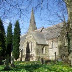
Church of St John the Evangelist
1.4 km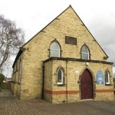
St Margaret
153 m
Bothal Mill House And Adjacent Outbuilding
1.5 km
Milestone 110 Metres South Of Vicarage
1.6 km
Conservatory Adjoining Longhirst Hall
1.6 km
Ruins Of Lady Chapel On North Bank Of River Wansbeck
1.5 km
The Joiners Shop
1.6 km
Numbers 1-7 North Farm
175 m
Cookswell House
569 m
Cottages Nos 5 And 6
1.6 km
Lych Gate to Churchyard
1.5 km
Gate Lodge 500 Metres South West Of Longhirst Hall
1.2 km
Garden Walls To South And East Of Pegswood Farm
141 m
Gate Piers And Screen Wall 500 Metres South West Of Longhirst Hall
1.2 km
Sundial 25 Metres South Of Longhirst Hall
1.5 km
Fire (Robin of Pegswood)
684 m
Bothal Viaduct
1.4 km
Colliers Hill
668 m
Cart Shed And Wall To West Of Pegswood Farm
177 m
Pegswood Farm
147 m
Milepost 530 Metres East Of A197/B1337 Road Junction
849 m
Garden And Terrace Walls To South Of Bothal Mill House
1.5 km
The Hall
1.5 km
Outbuilding 20 Metres North Of Pegswood Farm
142 m
Welfare Cinema
29 m
Farm Buildings And Wall To North East Of East Farmhouse
27 m
Village Hall And Attached House
1.6 km
Garden Walls To South Of East Farmhouse
9 mRecensioni
Ha visitato questo luogo? Tocchi le stelle per valutarlo e condividere la Sua esperienza o foto con la community! Provalo ora! Puoi annullarlo in qualsiasi momento.
Scopri tesori nascosti ad ogni viaggio!
Da piccoli caffè caratteristici a panorami nascosti, fuggi dalla folla e scova i posti che fanno davvero per te. La nostra app ti semplifica tutto: ricerca vocale, filtri furbi, percorsi ottimizzati e dritte autentiche da viaggiatori di tutto il mondo. Scaricala subito per vivere l'avventura sul tuo smartphone!

Un nuovo approccio alla scoperta turistica❞
— Le Figaro
Tutti i luoghi che meritano di essere esplorati❞
— France Info
Un’escursione su misura in pochi clic❞
— 20 Minutes