Raspit Hill, building in Ightham, Tonbridge and Malling, Kent, UK
Posizione: Ightham
Coordinate GPS: 51.27032,0.26619
Ultimo aggiornamento: 25 novembre 2023 alle 01:27
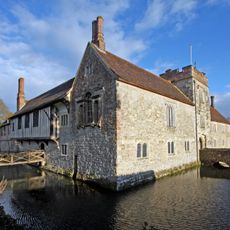
Ightham Mote
1.3 km
The Old House, Ightham Common
1.4 km
Mote Farm Cottages Old Laundry Cottage
1.3 km
Gibbon's Place
1.5 km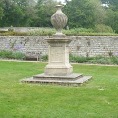
Garden Urn 30 Yards West Of Ightham Mote
1.3 km
Ightham Mote Medieval moated site
1.3 km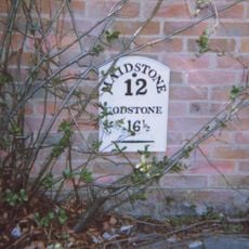
Milestone, Sevenoaks Road, in wall of "Oakenhurst"
916 m
Pond Farmhouse (Pond Lane)
829 m
The Old House
719 m
Lavender Plantation
1 km
Harrow Cottage
1.1 km
The Old Cottage The Workhouse
1.1 km
Langleys
1.2 km
East Mote Oast
1.2 km
Yew Tree Cottage
1.3 km
Bewley Farmhouse
1.3 km
Oast Building At Foxbury Farm
729 m
Lord's Spring Cottage Lord's Spring Cottages
1.3 km
Stone Street Farm Cottage
836 m
Forge Cottage
697 m
Fir Tree House
697 m
Stable Building 20 Yards To East Of Ightham Mote
1.4 km
Holly Tree Cottage
1.4 km
Gates, Gatepiers And Mounting Block To South West Of Ightham Mote
1.4 km
Ivors
683 m
Redwell
1.4 km
Mote Farmhouse
1.5 km
Oasthouse 75 Yards North Of Mote Farmhouse
1.5 kmRecensioni
Ha visitato questo luogo? Tocchi le stelle per valutarlo e condividere la Sua esperienza o foto con la community! Provalo ora! Puoi annullarlo in qualsiasi momento.
Scopri tesori nascosti ad ogni viaggio!
Da piccoli caffè caratteristici a panorami nascosti, fuggi dalla folla e scova i posti che fanno davvero per te. La nostra app ti semplifica tutto: ricerca vocale, filtri furbi, percorsi ottimizzati e dritte autentiche da viaggiatori di tutto il mondo. Scaricala subito per vivere l'avventura sul tuo smartphone!

Un nuovo approccio alla scoperta turistica❞
— Le Figaro
Tutti i luoghi che meritano di essere esplorati❞
— France Info
Un’escursione su misura in pochi clic❞
— 20 Minutes