
Milepost At National Grid Reference So 767 102
Milepost At National Grid Reference So 767 102, milestone in Longney and Epney, Stroud, Gloucestershire, UK
Posizione: Longney and Epney
Coordinate GPS: 51.79018,-2.33929
Ultimo aggiornamento: 10 novembre 2024 alle 16:13
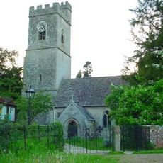
Whitminster Church
1.3 km
Church of St Peter
1.7 km
Church of St Stephen
1.4 km
Pa- - - - - Monument, About 4M South West Of South Door In Churchyard Of Church Of St Stephen
1.4 km
Two Hawkins Monuments, About 11M South West Of East End Of Chancel In Churchyard Of Church Of St Andrew
1.3 km
Baldwin House And Baldwin Cottage
1.2 km
Three Unidentified Monuments, In Line Immediately East Of North Porch In Churchyard Of Church Of St Stephen
1.4 km
Walk Farmhouse
1.6 km
Doris's Cottage
1.1 km
Lock And Lockgates Canal (North West Side Of Gloucester And Sharpness Canal, And Immedieatly West Of Bridge Over Same)
1.4 km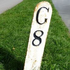
Milestone At National Grid Reference So 755 092
1.6 km
Milepost At National Grid Reference So 779 112
1.5 km
Whitminster House
1.4 km
Packthorne Farmhouse
666 m
Barn To North East Of Packthorne Farmhouse
658 m
Woodfield House With Perimeter Wall To North And West, Gates And Railings Linking On South Side
1.5 km
Lea Court Farm
1.1 km
Unidentified Monument, About 6M South East Of South Door In Churchyard Of Church Of St Stephen
1.4 km
Two Hewlett Monuments, About 1.5M East Of South Aisle In Churchyard Of Church Of St Stephen
1.4 km
Brewer Monument, About 10M South Of Priest's Door In Churchyard Of Church Of St Andrew
1.3 km
Parkend Bridge House
1.1 km
Three King Monuments, About 11M South Of Porch In Churchyard Of Church Of Church Of St Andrew
1.4 km
Moated site at Church Farm
1.3 km
Lock House
1.6 km
Oakey Farmhouse
1.3 km
Walls At Entrance To The Stroudwater Canal At So 751 105
1.6 km
Barracks Farmhouse
1.3 km
Combined Dovecote, Cartshed, Stable And Cowhouse To North West Of Yard At Moor Farm
266 mRecensioni
Ha visitato questo luogo? Tocchi le stelle per valutarlo e condividere la Sua esperienza o foto con la community! Provalo ora! Puoi annullarlo in qualsiasi momento.
Scopri tesori nascosti ad ogni viaggio!
Da piccoli caffè caratteristici a panorami nascosti, fuggi dalla folla e scova i posti che fanno davvero per te. La nostra app ti semplifica tutto: ricerca vocale, filtri furbi, percorsi ottimizzati e dritte autentiche da viaggiatori di tutto il mondo. Scaricala subito per vivere l'avventura sul tuo smartphone!

Un nuovo approccio alla scoperta turistica❞
— Le Figaro
Tutti i luoghi che meritano di essere esplorati❞
— France Info
Un’escursione su misura in pochi clic❞
— 20 Minutes