
135-141, Upper Stone Street, building in Maidstone, Kent, UK
Posizione: Maidstone
Coordinate GPS: 51.26707,0.52710
Ultimo aggiornamento: 25 novembre 2023 alle 01:29
College of All Saints, Maidstone
505 m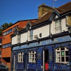
The Pilot Public House
320 m
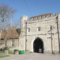
The Master's Tower
468 m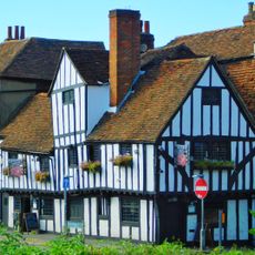
70 Lower Stone Street
406 m
50, Lower Stone Street
447 m
46, Lower Stone Street
452 m
6-10, Knightrider Street
411 m
The College
503 m
36, Lower Stone Street
479 m
52 And 54, Lower Stone Street
442 m
Corrall's Charity Almshouses
301 m
44, Lower Stone Street
456 m
58-68, Lower Stone Street
418 m
Knightrider House
448 m
Hunter's Almshouses
399 m
Cutbush Almshouses
439 m
56, Lower Stone Street
435 m
North Boundary Wall Formerly To Digons
431 m
All Saints Church Of England School
423 m
East Boundary Wall Formerly To Digons
410 m
64-70, Mote Road
404 m
The Fisherman's Arms Public House
462 m
Ruined Gateway
396 m
15, Knightrider Street
387 m
34, Lower Stone Street
490 m
Wren's Cross
368 m
11-14, Romney Place
503 m
1-10, Romney Place
505 mRecensioni
Ha visitato questo luogo? Tocchi le stelle per valutarlo e condividere la Sua esperienza o foto con la community! Provalo ora! Puoi annullarlo in qualsiasi momento.
Scopri tesori nascosti ad ogni viaggio!
Da piccoli caffè caratteristici a panorami nascosti, fuggi dalla folla e scova i posti che fanno davvero per te. La nostra app ti semplifica tutto: ricerca vocale, filtri furbi, percorsi ottimizzati e dritte autentiche da viaggiatori di tutto il mondo. Scaricala subito per vivere l'avventura sul tuo smartphone!

Un nuovo approccio alla scoperta turistica❞
— Le Figaro
Tutti i luoghi che meritano di essere esplorati❞
— France Info
Un’escursione su misura in pochi clic❞
— 20 Minutes