
48 And 50, Chipstead Lane, building in Riverhead, Sevenoaks, Kent, UK
Posizione: Riverhead
Coordinate GPS: 51.28436,0.16712
Ultimo aggiornamento: 25 novembre 2023 alle 01:29
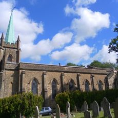
Church of St Mary
256 m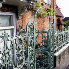
Forecourt Railings And Entrance Arch To The Manor House
160 m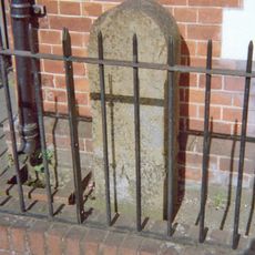
Milestone, Amherst Hill, Riverhead, nr jct with Worships Hill
253 m
84 And 86, Chipstead Lane
111 m
Piece Of Wall To South East Of Riverhead House
199 m
The Old Cottage
82 m
Stable Building To Rear Of The Old Farmhouse
62 m
Durham House
112 m
Coach House To West Of No 2 Wall West Of No 2
127 m
Cade House
152 m
The Manor House Nursing Home
153 m
Manor House Cottage
154 m
8, The Square
158 m
The Beehive Public House
49 m
7, The Square
166 m
Forecourt Railings To Riverhead House
172 m
The Old Farmhouse
74 m
Riverhead House
206 m
Wall To East And South Of Coach House Building
209 m
3 And 5, Maidstone Road
218 m
Old Outbuildings To North West Of The Riverhead Public House
222 m
Wall Running South, West South West And South Again From North West Corner Of Lane Belonging To The Riverhead Public House
232 m
Dovecot In Garden To West Of The Riverhead Public House
246 m
7, Linden Square
247 m
1-4, Linden Square
248 m
40-46, Chipstead Lane
14 m
52 And 54, Chipstead Lane
9 m
Wall To West Of The Riverhead Public House
266 mRecensioni
Ha visitato questo luogo? Tocchi le stelle per valutarlo e condividere la Sua esperienza o foto con la community! Provalo ora! Puoi annullarlo in qualsiasi momento.
Scopri tesori nascosti ad ogni viaggio!
Da piccoli caffè caratteristici a panorami nascosti, fuggi dalla folla e scova i posti che fanno davvero per te. La nostra app ti semplifica tutto: ricerca vocale, filtri furbi, percorsi ottimizzati e dritte autentiche da viaggiatori di tutto il mondo. Scaricala subito per vivere l'avventura sul tuo smartphone!

Un nuovo approccio alla scoperta turistica❞
— Le Figaro
Tutti i luoghi che meritano di essere esplorati❞
— France Info
Un’escursione su misura in pochi clic❞
— 20 Minutes