Longhouses, building in Brightling, Rother, East Sussex, UK
Posizione: Brightling
Coordinate GPS: 50.95840,0.40412
Ultimo aggiornamento: 20 novembre 2025 alle 21:03

Brightling Park
790 m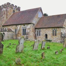
The Parish Church of St Thomas A Becket
832 m
The Steps And Entrance To The Church Yard With The Wall To The South West As Far As And Including The Gatepiers Of Brightling Park
793 m
Street Cottages
771 m
The Fuller's Arms Inn
1.2 km
Ox Lodge Cottages
425 m
Holly Tree Cottage
663 m
Garden Cottage
684 m
Stonesdown Cottage
783 m
The Hermit's Tower
267 m
Hollingrove Cottages
533 m
1 and 2 Twelve Oaks Cottages
154 m
Brightling Post Office With The House Attached
807 m
The Temple At Brightling Park To The South West Of The House
908 m
The Old School
783 m
White House
442 m
Hollingrove Barn
433 m
The Stables And Coach House Of Brightling Park To The South East Of The House
713 m
The Glebe House
744 m
Hollingrove Farmhouse
269 m
Long Reach Farmhouse
1.1 km
Step Houses
954 m
The Mausoleum Of John Fuller In The Churchyard To The South East Of The Church
792 m
Snail Farmhouse
598 m
The Saw Mill
457 m
The Stables Of The Fuller's Arms Inn
1.2 km
Becket House
789 m
1-4 River Houses
993 mRecensioni
Ha visitato questo luogo? Tocchi le stelle per valutarlo e condividere la Sua esperienza o foto con la community! Provalo ora! Puoi annullarlo in qualsiasi momento.
Scopri tesori nascosti ad ogni viaggio!
Da piccoli caffè caratteristici a panorami nascosti, fuggi dalla folla e scova i posti che fanno davvero per te. La nostra app ti semplifica tutto: ricerca vocale, filtri furbi, percorsi ottimizzati e dritte autentiche da viaggiatori di tutto il mondo. Scaricala subito per vivere l'avventura sul tuo smartphone!

Un nuovo approccio alla scoperta turistica❞
— Le Figaro
Tutti i luoghi che meritano di essere esplorati❞
— France Info
Un’escursione su misura in pochi clic❞
— 20 Minutes