Bridge House, house in Mersham, Ashford, Kent, UK
Posizione: Mersham
Coordinate GPS: 51.11721,0.92791
Ultimo aggiornamento: 24 novembre 2025 alle 01:12
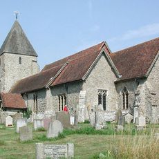
Church of St John the Baptist
247 m
The Farriers Arms
305 m
Brook Cottage
372 m
Goodrich Cottage
230 m
Loud House
549 m
Bell House
211 m
Mersham Manor
198 m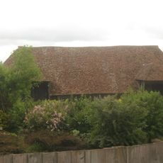
Barn About 30 Metres North West Of Mersham Manor
143 m
Tomb Chest To Elizabeth Mantel, About 20 Metres South Of Church Of St John
245 m
Hannover Mill, Outbuildings And Mill
317 m
Bower Cottages
449 m
16 And 16A, The Street
518 m
The Old Gate House Including Attached Raised Footway
529 m
Chestnut Villas
467 m
Winser Cottage
527 m
15, The Street
508 m
Burgate
565 m
Woods Stores, Post Office And Hollyhock Cottage
436 m
The Royal Oak And House/Office Attached
489 m
Flanders House
532 m
Stable Block About 20 Metres South East Of Woods Stores
432 m
Headstone To George Blechynden, About 4 Metres South East Of Church Of St John
250 m
Two Rows Of 3 And 5 Headstones About 5 To 15 Metres South Of Church Of St John
235 m
Stables/Outbuildings About 5 To 20 Metres South And West Of The Farriers Arms
322 m
Chest Tomb To Jane Morris (?) About 1 Metre South Of Church Of St John
239 m
Sundial 5 Metres South Of Church Of St John
230 m
K6 Telephone Kiosk
478 m
Punto di vista panoramico
304 mRecensioni
Ha visitato questo luogo? Tocchi le stelle per valutarlo e condividere la Sua esperienza o foto con la community! Provalo ora! Puoi annullarlo in qualsiasi momento.
Scopri tesori nascosti ad ogni viaggio!
Da piccoli caffè caratteristici a panorami nascosti, fuggi dalla folla e scova i posti che fanno davvero per te. La nostra app ti semplifica tutto: ricerca vocale, filtri furbi, percorsi ottimizzati e dritte autentiche da viaggiatori di tutto il mondo. Scaricala subito per vivere l'avventura sul tuo smartphone!

Un nuovo approccio alla scoperta turistica❞
— Le Figaro
Tutti i luoghi che meritano di essere esplorati❞
— France Info
Un’escursione su misura in pochi clic❞
— 20 Minutes