
3 4, Durham Road, building in Brancepeth, County Durham, UK
Posizione: Brancepeth
Coordinate GPS: 54.73676,-1.65582
Ultimo aggiornamento: 25 novembre 2023 alle 01:31
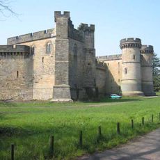
Brancepeth Castle
395 m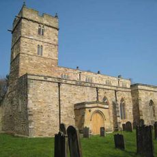
Church of St Brandon
404 m
Foster And Mills Slabs 4 Metres South Of Church Of St Brandon
418 m
Brancepeth Bridge
319 m
Magnolia Cottage
72 m
Driking Fountain In Wall To North East Of Number 12, The Villlage
55 m
5-9, The Village
72 m
Gate Piers, Gates, Overthrow And Stile 25 Metres North West Of Church Of St Brandon
361 m
1 2, Durham Road
18 m
2 3 3A 4, The Village
90 m
School House
92 m
Bastion 30 Metres South Of Brancepeth Castle
390 m
Hoppy Acres And Constable Meadows
148 m
Entrance Screen To North East Of Castle Lodge
151 m
Castle Lodge
164 m
2 Bastions And Terrace Wall 25 Metres West Of Brancepeth Castle
313 m
Coach House 15 Metres North East Of Number 12 The Village
42 m
Johnson Headstone 10 Metres South Of Church Of St Brandon
405 m
Brancepeth War Memorial
379 m
1, The Village
103 m
The Close
49 m
10 11, The Village
68 m
12, The Village
64 m
Thompson Monument 3 Metres South Of Church Of St Brandon
409 m
Wilson And Stockburn Headstones 10 Metres South Of Church Of St Brandon
415 m
Lamp Post 1.5 Metres West Of Number 12
73 m
Brancepeth Castle Golf Club
463 m
Ice House 120 Metres South Of Brancepeth Golf Club House
547 mRecensioni
Ha visitato questo luogo? Tocchi le stelle per valutarlo e condividere la Sua esperienza o foto con la community! Provalo ora! Puoi annullarlo in qualsiasi momento.
Scopri tesori nascosti ad ogni viaggio!
Da piccoli caffè caratteristici a panorami nascosti, fuggi dalla folla e scova i posti che fanno davvero per te. La nostra app ti semplifica tutto: ricerca vocale, filtri furbi, percorsi ottimizzati e dritte autentiche da viaggiatori di tutto il mondo. Scaricala subito per vivere l'avventura sul tuo smartphone!

Un nuovo approccio alla scoperta turistica❞
— Le Figaro
Tutti i luoghi che meritano di essere esplorati❞
— France Info
Un’escursione su misura in pochi clic❞
— 20 Minutes