Clayfields Mill, mill in Chalford, Stroud, Gloucestershire, UK
Posizione: Chalford
Coordinate GPS: 51.71986,-2.16331
Ultimo aggiornamento: 20 novembre 2025 alle 21:23
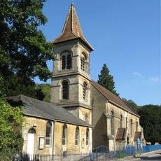
Christ Church
415 m
RMC: The cave
304 m
Iles's Mill Lock And Canal Bridge
15 m
St Marys House, Wing Cottage And Ivy Cottage
242 m
Woodbank Cottage
449 m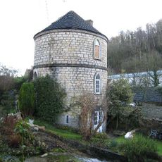
Canal Round House
363 m
Iles Mill Cottage
50 m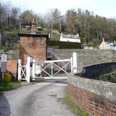
Signal Box At Brimscombe St Mary's Crossing
256 m
Canal Overflow Weir In Garden To West Of Canal Round House
355 m
Firwood
309 m
Crossing Gates At Brimscombe St Mary's Crossing
246 m
Road Bridge Over Mill Stream Approximately 50M East Of Belvedere Mill
359 m
Skaiteshill House
132 m
Chalford Place
387 m
Wharf House And Adjacent Workshop
403 m
Retaining Wall Including Steps,Sundial And Doorway Approximately 40M West Of Skaiteshill House
154 m
Mill Building And Chimney Stack Approximately 20M North East Of St Mary's Mill
294 m
Chalford Church Room
389 m
Belvedere Mill
302 m
St Mary's Mill
329 m
Brookside (Iles's Mill) Including Garden Wall To North
50 m
St Marys Farm
349 m
Chalford War Memorial
449 m
Belvedere House
228 m
Coach House Approximately 30M North East Of Skaiteshill House
169 m
Gateway Approximately 100 Metres North East Of Skaiteshill House
185 m
Stable And Coachhouse Approximately 30 Metres To North West Of Firwood
345 m
Mount Cottage
52 mRecensioni
Ha visitato questo luogo? Tocchi le stelle per valutarlo e condividere la Sua esperienza o foto con la community! Provalo ora! Puoi annullarlo in qualsiasi momento.
Scopri tesori nascosti ad ogni viaggio!
Da piccoli caffè caratteristici a panorami nascosti, fuggi dalla folla e scova i posti che fanno davvero per te. La nostra app ti semplifica tutto: ricerca vocale, filtri furbi, percorsi ottimizzati e dritte autentiche da viaggiatori di tutto il mondo. Scaricala subito per vivere l'avventura sul tuo smartphone!

Un nuovo approccio alla scoperta turistica❞
— Le Figaro
Tutti i luoghi che meritano di essere esplorati❞
— France Info
Un’escursione su misura in pochi clic❞
— 20 Minutes