
Ramhurst Farmhouse, farmhouse in Headcorn, Maidstone, Kent, UK
Posizione: Headcorn
Coordinate GPS: 51.17707,0.60833
Ultimo aggiornamento: 25 novembre 2023 alle 01:32
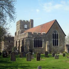
St Peter's and St Paul's Church, Headcorn
1.3 km
Headcorn Manor
1.2 km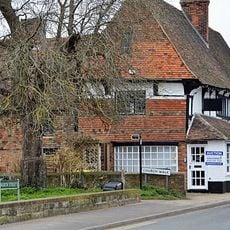
Cloth Hall
1.3 km
Old Plumtrees
510 m
Barn At Tq 829 449
583 m
Mounting Block And Path About 4 Metres North West Of Kelsham Farmhouse
1.3 km
Kelsham Farmhouse
1.3 km
1 and 2, Moat Road
1.2 km
Tilden
1.2 km
Milestone, Mill Bank, N of Bankfields and the bench
988 m
The Moat
1.1 km
Table tomb about 5 metres south of South Porch of Church of St Peter and St Paul
1.3 km
Glebe Cottage Heron Cottage Church Cottage
1.2 km
Oast House About 10 Metres East Of Kelsham Farmhouse
1.3 km
9 and 10, Church Walk
1.3 km
Four Oaks
1.2 km
Hearnden Farmhouse
1.3 km
Barn About 73 Metres South West Of Moatenden Priory
1.3 km
Hazelpits Farmhouse
952 m
Oasthouse About 10 Metres North Of Tilden
1.2 km
Stephens Bridge
885 m
Table tomb about 2 metres south of the south chapel of Church of St Peter and St Paul
1.3 km
Petite Cottage, Bless Cottage And Weavers Cottage
1.3 km
Table tomb about 10 metres east of Chancel of Church of St Peter and St Paul
1.3 km
Table tomb about 5 metres south of South Chapel of Church of St Peter and St Paul
1.3 km
Maltmans
564 m
1,2,3,4, Church Walk
1.3 km
Moatenden Priory
1.3 kmRecensioni
Ha visitato questo luogo? Tocchi le stelle per valutarlo e condividere la Sua esperienza o foto con la community! Provalo ora! Puoi annullarlo in qualsiasi momento.
Scopri tesori nascosti ad ogni viaggio!
Da piccoli caffè caratteristici a panorami nascosti, fuggi dalla folla e scova i posti che fanno davvero per te. La nostra app ti semplifica tutto: ricerca vocale, filtri furbi, percorsi ottimizzati e dritte autentiche da viaggiatori di tutto il mondo. Scaricala subito per vivere l'avventura sul tuo smartphone!

Un nuovo approccio alla scoperta turistica❞
— Le Figaro
Tutti i luoghi che meritano di essere esplorati❞
— France Info
Un’escursione su misura in pochi clic❞
— 20 Minutes