Chantry Mill, mill in Storrington and Sullington, Horsham, West Sussex, UK
Posizione: Storrington and Sullington
Coordinate GPS: 50.91355,-0.44766
Ultimo aggiornamento: 25 novembre 2023 alle 01:32
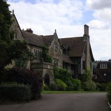
The Abbey, Storrington
642 m
31 and 33, Church Street
630 m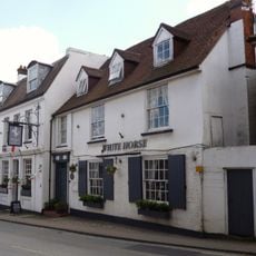
The Old Market Rooms The White Horse Hotel
643 m
Brook Cottage
503 m
Mulberry House
661 m
Byne
472 m
The Old House Cottage
374 m
10-14, Brewers Yard
657 m
1 and 3, School Hill
558 m
Pair of bowl barrows 280m SE of Trinity Methodist Church, forming part of a round barrow cemetery on Sullington Warren
573 m
18 20 And 22, High Street
597 m
Animal Fare The Old Forge
666 m
Brook House
490 m
Bowl barrow 200m SE of Trinity Methodist Church, forming part of a round barrow cemetery on Sullington Warren
630 m
Orchard Dale
654 m
Emmas Market And Old Rosemary
635 m
16 And 17, Brewers Yard
638 m
Abbey Convent
641 m
9, High Street
613 m
2, School Hill
536 m
Gateway At The North West Corner Of The Kitchen Garden Wall Of St Joseph's Dominican Convent At The Corner Of Brown's Lane And Church Street
634 m
The Palace
655 m
11, West Street
655 m
7 And 9, West Street
656 m
Georgian House Including Front Garden Railing To East
657 m
Nifty Art Gallery
532 m
2 And 4, East Brook
519 m
No 41 And The Garden Wall And Gate Piers To South East
661 mRecensioni
Ha visitato questo luogo? Tocchi le stelle per valutarlo e condividere la Sua esperienza o foto con la community! Provalo ora! Puoi annullarlo in qualsiasi momento.
Scopri tesori nascosti ad ogni viaggio!
Da piccoli caffè caratteristici a panorami nascosti, fuggi dalla folla e scova i posti che fanno davvero per te. La nostra app ti semplifica tutto: ricerca vocale, filtri furbi, percorsi ottimizzati e dritte autentiche da viaggiatori di tutto il mondo. Scaricala subito per vivere l'avventura sul tuo smartphone!

Un nuovo approccio alla scoperta turistica❞
— Le Figaro
Tutti i luoghi che meritano di essere esplorati❞
— France Info
Un’escursione su misura in pochi clic❞
— 20 Minutes