
Bredgar War Memorial, memorial in Bredgar, Swale, Kent, UK
Posizione: Bredgar
Coordinate GPS: 51.31219,0.69664
Ultimo aggiornamento: 17 novembre 2025 alle 00:13
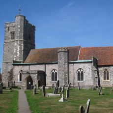
Church of St John the Baptist
137 m
Wesley Chapel, Wesley Cottage And Holly Cottage
313 m
Oakwood Gate Cottage
660 m
Bush House
218 m
Brickwall And Railings To Forecourt
225 m
Kingsdown Cottage Nether Cottage
416 m
Burnham House
97 m
Mann's Place
501 m
Chimneys
188 m
Wall Running South Of Brickwall
243 m
Chantry House
78 m
Parsonage Farmhouse
482 m
Primrose House
55 m
Silver Street Farmhouse
522 m
North Bank Cottages
374 m
Bredgar House
37 m
Downings
301 m
Carthouse 20 Yards West Of Parsonage Farm
486 m
Stiff Street Farmhouse
927 m
Chantries
132 m
Dovecot 25 Yards North West Of Chantry House
55 m
The Vicarage
381 m
Barn, 15 Yards North East Of Downsell's Cottage
982 m
Barn 20 Yards South West Of Gibben's Farm Bungalow
117 m
Brewer's House
114 m
The Firs
665 m
K6 Telephone Kiosk To North West Of Parish Church
133 m
Barn 15 Yards South Of Silver Street Farmhouse
540 mRecensioni
Ha visitato questo luogo? Tocchi le stelle per valutarlo e condividere la Sua esperienza o foto con la community! Provalo ora! Puoi annullarlo in qualsiasi momento.
Scopri tesori nascosti ad ogni viaggio!
Da piccoli caffè caratteristici a panorami nascosti, fuggi dalla folla e scova i posti che fanno davvero per te. La nostra app ti semplifica tutto: ricerca vocale, filtri furbi, percorsi ottimizzati e dritte autentiche da viaggiatori di tutto il mondo. Scaricala subito per vivere l'avventura sul tuo smartphone!

Un nuovo approccio alla scoperta turistica❞
— Le Figaro
Tutti i luoghi che meritano di essere esplorati❞
— France Info
Un’escursione su misura in pochi clic❞
— 20 Minutes