
Water Pump, In The Fork Of The Side Road On The Left
Water Pump, In The Fork Of The Side Road On The Left, well in Avening, Cotswold, Gloucestershire, UK
Posizione: Avening
Coordinate GPS: 51.67952,-2.16956
Ultimo aggiornamento: 19 novembre 2025 alle 05:40
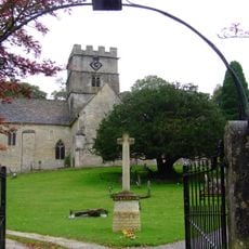
Church of the Holy Cross, Avening
430 m
Unidentified Memorial, About 12 Metres North West Of Porch In The Churchyard Of Church Of Holy Cross
454 m
Group Of 3 Unidentified Memorials About 15 Metres North West Of Porch In Churchyard Of Church Of The Holy Cross
456 m
Unidentified Memorial, About 16 Metres North West Of Porch In Churchyard Of Church Of Holy Cross
451 m
Barrett Memorial, About 21 Metres West Of Porch In Churchyard Of Church Of The Holy Cross
469 m
Glebe House
318 m
Sandford House
331 m
Old Quarries
433 m
2 And 4, Rectory Lane
316 m
Brook House
225 m
The Old Rectory
469 m
54, High Street
375 m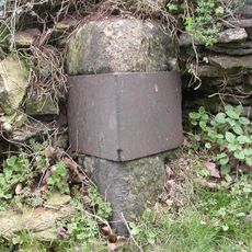
Milestone, Tetbury Hill, S village
184 m
Hanslo House
80 m
20, Woodstock Lane
602 m
Mullions, Adjacent To Churchyard Of Church Of Holy Cross On West Side, And Garden Wall
445 m
Unidentified Memorial, About 15 Metres North West Of Porch In Churchyard Of Church Of The Holy Cross
452 m
Unidentified Memorial, About 7 Metres South West Of Doorway In Churchyard Of Avening Baptist Chapel
28 m
25, Point Road
305 m
Cartshed With Granary Over And Attached Cow Shelter Adjoining Church Farmhouse On West
469 m
Church Farmhouse
443 m
K6 Telephone Kiosk
94 m
Water Pump, By The Shoe Box
73 m
Water Pump, Located In The Fork At The Top Of Lane
494 m
Water Pump, By The Old Garage At Bottom Of Lane
592 m
Water Pump, Halfway Along, On The Left
198 m
Water Pump, Next To The Bell Inn
330 m
Barn at Church Farm, on West Side of Farmyard
478 mRecensioni
Ha visitato questo luogo? Tocchi le stelle per valutarlo e condividere la Sua esperienza o foto con la community! Provalo ora! Puoi annullarlo in qualsiasi momento.
Scopri tesori nascosti ad ogni viaggio!
Da piccoli caffè caratteristici a panorami nascosti, fuggi dalla folla e scova i posti che fanno davvero per te. La nostra app ti semplifica tutto: ricerca vocale, filtri furbi, percorsi ottimizzati e dritte autentiche da viaggiatori di tutto il mondo. Scaricala subito per vivere l'avventura sul tuo smartphone!

Un nuovo approccio alla scoperta turistica❞
— Le Figaro
Tutti i luoghi che meritano di essere esplorati❞
— France Info
Un’escursione su misura in pochi clic❞
— 20 Minutes