
Sir Richard's Presbytery, architectural structure in Slindon, Arun, West Sussex, UK
Posizione: Slindon
Coordinate GPS: 50.86788,-0.63563
Ultimo aggiornamento: 20 novembre 2025 alle 20:03
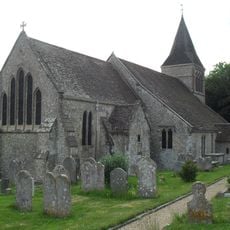
The Parish Church of St Mary
142 m
2, Church Hill
57 m
16 and 17, Church Hill
210 m
9 and 10, Church Hill
87 m
Church House
166 m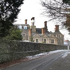
Slindon House
102 m
18, Dyer's Lane
208 m
19, Dyer's Lane
210 m
The Conservatory At Slindon House To The North West Of The House
135 m
The Lodge Of Slindon House To The North West Of The House
155 m
The Stables Of Church House To The South East Of The House
206 m
Tower In The Grounds Of Slindon House To The North West Of The House And Wall Adjoining This On The North
172 m
The Old Post
111 m
Yew Tree Cottage
125 m
Bailiff's House
196 m
Ember Cottage
226 m
Roman Catholic Church of St Richard
23 m
Slindon War Memorial
155 m
No. 1 Slindon
52 m
7, Church Hill
76 m
5, Top Road
86 m
Lime Tree House
65 m
Dower House
99 m
The Cottage
218 m
The Hermitage
93 m
Old Inn House
107 m
13, 14 and 15, Church Hill
137 m
Mulberry House
242 mRecensioni
Ha visitato questo luogo? Tocchi le stelle per valutarlo e condividere la Sua esperienza o foto con la community! Provalo ora! Puoi annullarlo in qualsiasi momento.
Scopri tesori nascosti ad ogni viaggio!
Da piccoli caffè caratteristici a panorami nascosti, fuggi dalla folla e scova i posti che fanno davvero per te. La nostra app ti semplifica tutto: ricerca vocale, filtri furbi, percorsi ottimizzati e dritte autentiche da viaggiatori di tutto il mondo. Scaricala subito per vivere l'avventura sul tuo smartphone!

Un nuovo approccio alla scoperta turistica❞
— Le Figaro
Tutti i luoghi che meritano di essere esplorati❞
— France Info
Un’escursione su misura in pochi clic❞
— 20 Minutes