
Hunstanworth Farm North Range
Hunstanworth Farm North Range, architectural structure in Hunstanworth, County Durham, UK
Posizione: Hunstanworth
Coordinate GPS: 54.83651,-2.07917
Ultimo aggiornamento: 25 novembre 2023 alle 01:41
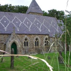
Church of St James
121 m
Townfield Cottages
763 m
South View Cottage The Cottage
92 m
Corner Cottage Mansion Cottage
61 m
Hunstanworth Farm West Range
22 m
Giant's Stride, West Of The Old School, In Former Schoolyard
706 m
Hunstanworth Farmhouse
37 m
Outbuilding North Of Townfield House
675 m
Walls On North Side Of Village Street In Front Of South View, Woodside Cottage, The Cottage, Mansion Cottage, Corner Cottage And The Vicarage, With Gate Piers And Gates
64 m
Courtyard And Orchard Walls In Front Of Stable Block
122 m
Walls Enclosing Garden And Yard Of Townfield House
671 m
Stable Block Of Former Vicarage
120 m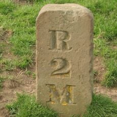
Milestone, Newbiggin, N bank of Beldon Burn, Blanchland Moor
1.1 km
Hunstanworth Farm East Byre Range
30 m
Tower house in the churchyard of St James's Church
146 m
The Old School
702 m
Moor View (House Opposite Church, Shown As Os Map As Shangri La)
172 m
School House
716 m
Walls, Piers And Gates Enclosing Yard Of Church Of St James
156 m
Range To East Of Hunstanworth Farm East Byre Range
54 m
High Garden House
689 m
Townfield House
689 m
Former School And House Attached (Old Church House)
118 m
Walls And Gate In Front Of Hunstanworth Farma Nd Farmhouse
31 m
West End, Pine Cottage And Ivy Cottage, With Area Wall And Gates
214 m
Walls Around Former Schoolyard, And Letter Box
737 m
Walls In Front Of Townfield Cottages
749 m
Walls On South Side Of Village Street In Front Of Ivy Cottage, Moor View And Old Church House
89 mRecensioni
Ha visitato questo luogo? Tocchi le stelle per valutarlo e condividere la Sua esperienza o foto con la community! Provalo ora! Puoi annullarlo in qualsiasi momento.
Scopri tesori nascosti ad ogni viaggio!
Da piccoli caffè caratteristici a panorami nascosti, fuggi dalla folla e scova i posti che fanno davvero per te. La nostra app ti semplifica tutto: ricerca vocale, filtri furbi, percorsi ottimizzati e dritte autentiche da viaggiatori di tutto il mondo. Scaricala subito per vivere l'avventura sul tuo smartphone!

Un nuovo approccio alla scoperta turistica❞
— Le Figaro
Tutti i luoghi che meritano di essere esplorati❞
— France Info
Un’escursione su misura in pochi clic❞
— 20 Minutes