
Colony Hall, architectural structure in Miserden, Stroud, Gloucestershire, UK
Posizione: Miserden
Coordinate GPS: 51.79272,-2.11844
Ultimo aggiornamento: 25 novembre 2023 alle 01:45

Rough Bank, Miserden
2.1 km
Foston's Ash Inn
1.1 km
Partridge Family Monument In The Churchyard Approximately 2 Metres West Of Tower To Church Of St Andrew
2.3 km
Group Of 10 Monuments In The Churchyard Approximately 2 Metres South Of Tower To Church Of St Andrew
2.3 km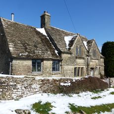
Tudor Cottage
2.2 km
Hazel Manor
848 m
Morcombe Farmhouse
2.2 km
Stable Approximately 40 Metres To North East Of Honeycombe Farmhouse
1.5 km
Wishanger Farmhouse
994 m
Bowl barrow, known as New Seal Wood barrow, 70m north east of Clements Farm
867 m
Main Range Of Farm Buildings And Barn At Wishanger Farm
924 m
New Inn House With Barn
1.2 km
Ebworth Farm With Stable And Coach House
2.1 km
Camp Farm Barn
1.2 km
Manless Town medieval settlement and the buried remains of a Roman camp
1.5 km
Long barrow, 575m north-west of Lypiatt Farm
1.9 km
The Camp long barrow
1.5 km
Bowl barrow, known as Buck's Head round barrow, 540m east of Dunley
2.2 km
Two bowl barrows, known as Climperwell round barrows, 310m south west of Climperwell Farm
1.5 km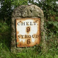
Milestone, Sheepscombe; 250m W crossroads to Sheepscombe & Miserden
1.5 km
Granary And Cartshed Approximately 30 Metres West Of Main Range Of Farm Buildings At Wishanger Farm
934 m
Caudle Green mounds
1.5 km
Honeycombe Farmhouse
1.5 km
Stoneyhill Farmhouse
2.1 km
Barn And Stable Immediately South West Of Wishanger Farmhouse
1 km
Barn Approximately 30 Metres To North Of Honeycombe Farmhouse
1.5 km
Honeysuckle Cottage And The Ferns
1.3 km
Group Of 5 Mainly Butcher Family Monuments In The Churchyard Approximately 3 Metres South West Of Tower To Church Of St Andrew
2.3 kmRecensioni
Ha visitato questo luogo? Tocchi le stelle per valutarlo e condividere la Sua esperienza o foto con la community! Provalo ora! Puoi annullarlo in qualsiasi momento.
Scopri tesori nascosti ad ogni viaggio!
Da piccoli caffè caratteristici a panorami nascosti, fuggi dalla folla e scova i posti che fanno davvero per te. La nostra app ti semplifica tutto: ricerca vocale, filtri furbi, percorsi ottimizzati e dritte autentiche da viaggiatori di tutto il mondo. Scaricala subito per vivere l'avventura sul tuo smartphone!

Un nuovo approccio alla scoperta turistica❞
— Le Figaro
Tutti i luoghi che meritano di essere esplorati❞
— France Info
Un’escursione su misura in pochi clic❞
— 20 Minutes