Sandyford House

Accedi al tuo account

AroundUs è una mappa collaborativa di luoghi interessanti, costruita da esploratori curiosi come te. Cresce con ogni recensione, storia e foto che condividi.
Accedi per salvare i tuoi posti preferiti, contribuire con nuovi luoghi e creare percorsi personalizzati.
Continua con Google
Continua con Apple
Continua con X
Continua con Facebook
Continua con email
Continuando, accetti i nostri Termini e Condizioni e la nostra Informativa sulla Privacy
Creare un account
Aggiungi alla collezione
Mappa
Suggerisci una modifica
Condividere

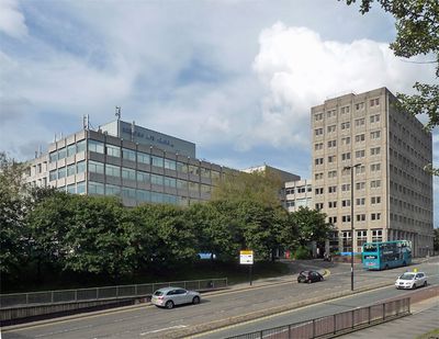
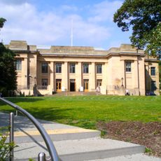
Sandyford House, Edificio per uffici nel quartiere Sandyford, Newcastle upon Tyne, Inghilterra.

Sandyford House è un edificio per uffici di sei piani con costruzione in cemento armato ed elementi di facciata in vetro situato su Sandyford Road. La struttura è stata originariamente concepita come centro amministrativo e fa parte di un complesso commerciale più ampio in questo distretto.

L'edificio è stato la sede principale del Consiglio della contea di Tyne and Wear dal 1974 al 1986. Successivamente ha ospitato le operazioni del Dipartimento della sicurezza sociale prima di passare a altri usi negli anni seguenti.

L'edificio è stato sede delle redazioni di Viz, una rivista di fumetti satirici che ha sviluppato un pubblico fedele in tutta la Gran Bretagna. Rappresenta un luogo importante per la creazione artistica indipendente in città.

L'edificio è attualmente in fase di conversione in appartamenti residenziali con piani approvati per un importante progetto di rigenerazione urbana. I visitatori devono essere consapevoli che l'accesso potrebbe essere limitato durante i lavori di costruzione.

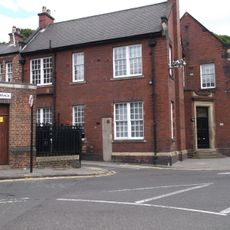
Il sito includeva originariamente il pub Royal Archer, riconosciuto dal Royal Institute of British Architects nel 1976. Questo pub locale era una parte consolidata della comunità prima dello sviluppo del complesso.

Posizione: Newcastle upon Tyne

Coordinate GPS: 54.98150,-1.60580

Ultimo aggiornamento: 14 dicembre 2025 alle 10:41

Foto
Intorno a questo luogo
Newcastle Civic Centre
Regno Unito

Newcastle Civic Centre

428 m
Great North Museum: Hancock
Regno Unito

Great North Museum: Hancock

489 m
Faculty of Humanities and Social Sciences
Regno Unito

Faculty of Humanities and Social Sciences

354 m
Jesmond Parish Church
Regno Unito

Jesmond Parish Church

101 m
Jesmond Old Cemetery
Regno Unito

Jesmond Old Cemetery

460 m
Jesmond Synagogue
Regno Unito

Jesmond Synagogue

465 m
Hutton Terrace drill hall
Regno Unito

Hutton Terrace drill hall

334 m
Armstrong Memorial
Regno Unito

Armstrong Memorial

496 m
Tomb Of John Dobson About 175 Metres South Of Jesmond Cemetery Gates
Regno Unito

Tomb Of John Dobson About 175 Metres South Of Jesmond Cemetery Gates

372 m
Church of St James with Hall, Sunday School and House Attached
Regno Unito

Church of St James with Hall, Sunday School and House Attached

490 m
8-13, Brandling Park
Regno Unito

8-13, Brandling Park

424 m
Tomb Of Keenleyside Family About 80 Metres South Of Jesmond Cemetery Gates
Regno Unito

Tomb Of Keenleyside Family About 80 Metres South Of Jesmond Cemetery Gates

449 m
Tomb Of Tm Richardson About 20 Metres South West Of Jesmond Cemetery Gateway
Regno Unito

Tomb Of Tm Richardson About 20 Metres South West Of Jesmond Cemetery Gateway

435 m
Hancock Museum of Natural History building
Regno Unito

Hancock Museum of Natural History building

483 m
21, Brandling Park
Regno Unito

21, Brandling Park

493 m
United Bus Company Depot
Regno Unito

United Bus Company Depot

247 m
The Carriage Public House
Regno Unito

The Carriage Public House

79 m
River God Tyne
Regno Unito

River God Tyne

463 m
Former Boiler House, Sandyford Brewery
Regno Unito

Former Boiler House, Sandyford Brewery

388 m
Tomb Of A Reed About 100 Metres South West Of Jesmond Cemetery Gates
Regno Unito

Tomb Of A Reed About 100 Metres South West Of Jesmond Cemetery Gates

362 m
Carlton Terrace
Regno Unito

Carlton Terrace

294 m
Deuchar House
Regno Unito

Deuchar House

337 m
34-46, Brandling Place South
Regno Unito

34-46, Brandling Place South

410 m
Tomb Of Joseph Wilson About 35 Metres South West Of Jesmond Cemetery Gateway
Regno Unito

Tomb Of Joseph Wilson About 35 Metres South West Of Jesmond Cemetery Gateway

414 m
Piers From Hospital Of The Virgin Mary Of Royal Grammar School
Regno Unito

Piers From Hospital Of The Virgin Mary Of Royal Grammar School

158 m
22-28, Brandling Place South
Regno Unito

22-28, Brandling Place South

445 m
31, 32 And 33, Brandling Place South
Regno Unito

31, 32 And 33, Brandling Place South

423 m
Entrance Archway, Pair Of Chapel Lodges, Walls And Gates To Jesmond Cemetery
Regno Unito

Entrance Archway, Pair Of Chapel Lodges, Walls And Gates To Jesmond Cemetery

465 m
Mostra la mappa completa
Recensioni

Ha visitato questo luogo? Tocchi le stelle per valutarlo e condividere la Sua esperienza o foto con la community! Provalo ora! Puoi annullarlo in qualsiasi momento.

« Sandyford House - Edificio per uffici nel quartiere Sandyford, Newcastle upon Tyne, Inghilterra » è fornito da Around Us (it.aroundus.com). Le immagini e i testi sono tratti dal progetto Wikimedia con licenza Creative Commons. È possibile copiare, distribuire e modificare copie di questa pagina, alle condizioni stabilite dalla licenza, a condizione che questa nota sia chiaramente visibile.

Scopri tesori nascosti ad ogni viaggio!

Da piccoli caffè caratteristici a panorami nascosti, fuggi dalla folla e scova i posti che fanno davvero per te. La nostra app ti semplifica tutto: ricerca vocale, filtri furbi, percorsi ottimizzati e dritte autentiche da viaggiatori di tutto il mondo. Scaricala subito per vivere l'avventura sul tuo smartphone!

Around Us App Screenshot

Un nuovo approccio alla scoperta turistica

Le Figaro

Tutti i luoghi che meritano di essere esplorati

France Info

Un’escursione su misura in pochi clic

20 Minutes