Druridge Bay Country Park, Parco rurale a Northumberland, Regno Unito
Il Druridge Bay Country Park è un parco costiero nel Northumberland con sette miglia di spiaggia sabbiosa, un lago artificiale e colline boscose. Il paesaggio include prati e zone boschive che creano un mix di spazi aperti e riparati per esplorare.
Il sito era una miniera di carbone a cielo aperto fino alla sua chiusura nel 1983, dopoché il terreno è stato trasformato in un parco pubblico. L'antica caverna mineraria è stata allagata per creare il Ladyburn Lake, che ora forma il centro del paesaggio.
Il parco ospita regolari eventi parkrun il sabato e festival stagionali che riuniscono i residenti locali. Questi raduni sono diventati occasioni sociali importanti che caratterizzano come la comunità usa lo spazio.
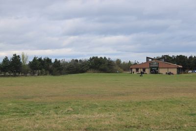
Un centro visitatori, una caffetteria e servizi igienici sono disponibili in tutto il parco, insieme a parcheggio e aree designate per gli sport acquatici. La maggior parte delle strutture è accessibile durante le ore diurne, e sentieri chiari facilitano la navigazione.
La costa conserva strutture difensive della Seconda Guerra Mondiale, tra cui blocchi anticarro e bunker in cemento. Questi resti rimangono visibili durante le passeggiate sulla spiaggia e raccontano la storia della difesa costiera.
La comunità dei viaggiatori curiosi
AroundUs riunisce migliaia di luoghi selezionati, consigli locali e gemme nascoste, arricchiti ogni giorno da oltre 60,000 contributori in tutto il mondo.