The Old Vicarage, clergy house in King's Stanley, Stroud, Gloucestershire, UK
Posizione: King's Stanley
Coordinate GPS: 51.73541,-2.24074
Ultimo aggiornamento: 21 novembre 2025 alle 03:08
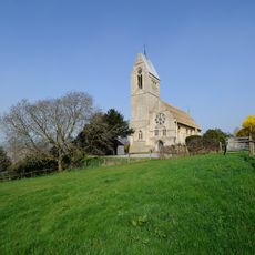
Selsley Church
630 m
Ivy Cottage
508 m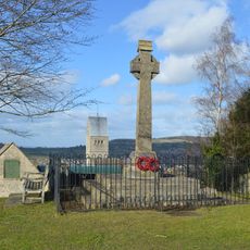
Selsley War Memorial
655 m
Stanley Park
487 m
Lower Dudbridge House
413 m
Flour Mill
401 m
Peaked Elm Farmhouse
718 m
Cotswold Mills House
634 m
Bay Tree House
574 m
Lamp Post To South Of The Lodge
265 m
Dudbridge House
289 m
Retaining Wall And Gatepiers To West Of The Old Vicarage
24 m
Gladfield Gardens
697 m
Gateway To South Of Stanley Park
502 m
Lych Gate To South Of Church Of All Saints
633 m
Milestone, Dudbridge Road, Rodborough
441 m
No. 23 (Stanley Park Lodge) With Archway No. 24 (The Clock House)No. 25 (Stable Cottage), The Stirrups And Nos 9 And 10
531 m
Lightpill Mill
494 m
Stanleyend Farmhouse
290 m
Cider House At Gordon Park Farm
391 m
Column Monument Approx 300M To North West Of Stanley Park
627 m
Meadow End
481 m
Crane At Dudbridge Wharf
706 m
The Lodge
272 m
Blue Row
454 m
Bell Inn And Adjoining Shop
208 m
The Green
211 m
Kitchen Garden Walls And Gates, To South West Of Stanley Park
596 mRecensioni
Ha visitato questo luogo? Tocchi le stelle per valutarlo e condividere la Sua esperienza o foto con la community! Provalo ora! Puoi annullarlo in qualsiasi momento.
Scopri tesori nascosti ad ogni viaggio!
Da piccoli caffè caratteristici a panorami nascosti, fuggi dalla folla e scova i posti che fanno davvero per te. La nostra app ti semplifica tutto: ricerca vocale, filtri furbi, percorsi ottimizzati e dritte autentiche da viaggiatori di tutto il mondo. Scaricala subito per vivere l'avventura sul tuo smartphone!

Un nuovo approccio alla scoperta turistica❞
— Le Figaro
Tutti i luoghi che meritano di essere esplorati❞
— France Info
Un’escursione su misura in pochi clic❞
— 20 Minutes