Blue House Pub
Posizione: Sunderland
Creatore: Frank Doyle
Creatore: Frank Doyle
Coordinate GPS: 54.89230,-1.36604
Ultimo aggiornamento: 9 novembre 2025 alle 15:56
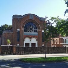
Sunderland Synagogue
872 m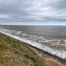
Hendon Beach
673 m
1-24, Park Place West
1.1 km
1-24, Park Place East
1.1 km
North Lodge Of Sunderland Cemetery
967 m
Langham Tower (Sunderland High School)
1.1 km
Gas Holder At Nz 4080 5544 To East Of East End Of Corporation Road
48 m
South Chapel Of Sunderland Cemetery
1.1 km
Fountain 5 Metres South East Of Sunderland Cemetery North Chapel
1 km
17-23, Saint Bede's Terrace
1.1 km
Ashburne House, Part Of Backhouse Building Of The University Of Sunderland
958 m
Christ Church Including Attached Vestry And Verger's House
1.1 km
Walls, Piers And Gates To Gray House
1 km
3-19, Ridley Terrace
713 m
Entrance Gates, Piers And Front Railings To Sunderland Cemetery
1 km
Carlton House
1.1 km
Terrace Walls And Piers To Ashburne House
949 m
Church of St Aidan
902 m
11, Mowbray Road
1.1 km
Gray House
994 m
West Hendon House
1.1 km
South Lodge of Sunderland Cemetery
993 m
Walls, Railings And Gates To Christ Church
1.1 km
North Chapel Of Sunderland Cemetery
992 m
War Memorial South of Christ Church
1.1 km
Church of St Ignatius
895 m
Grafters Gable (a unique combination of street art and storytelling)
549 m
Bede Tower
1.2 kmRecensioni
Ha visitato questo luogo? Tocchi le stelle per valutarlo e condividere la Sua esperienza o foto con la community! Provalo ora! Puoi annullarlo in qualsiasi momento.
Scopri tesori nascosti ad ogni viaggio!
Da piccoli caffè caratteristici a panorami nascosti, fuggi dalla folla e scova i posti che fanno davvero per te. La nostra app ti semplifica tutto: ricerca vocale, filtri furbi, percorsi ottimizzati e dritte autentiche da viaggiatori di tutto il mondo. Scaricala subito per vivere l'avventura sul tuo smartphone!

Un nuovo approccio alla scoperta turistica❞
— Le Figaro
Tutti i luoghi che meritano di essere esplorati❞
— France Info
Un’escursione su misura in pochi clic❞
— 20 Minutes