
The 'Tannery', To South East Of High Shield House
The 'Tannery', To South East Of High Shield House, building in Hexham, Northumberland, UK
Posizione: Hexham
Coordinate GPS: 54.96113,-2.10293
Ultimo aggiornamento: 4 novembre 2025 alle 09:55
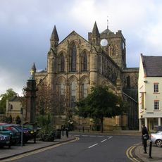
Abbazia di Hexham
697 m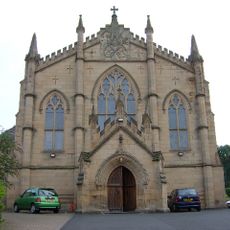
Church of St Mary (Roman Catholic)
918 m
Catholic Club
907 m
Bridge And Causeway Over Halgut Burn
813 m
Benson Of Allerwash Memorial Gates Gates To The Sele At Junction With Battlehill
984 m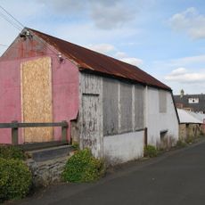
The Ropery, Now The Argyle Cafe
979 m
Hackwood
430 m
Middle Shield House
112 m
Hencotes House
985 m
19 And 21, Battlehill
978 m
4, Battlehill
974 m
Remains Of Former Number 20
956 m
Roman Catholic Presbytery
957 m
18 And 18A, Eastgate
891 m
16 And 18, Hencotes
985 m
Burn Brae House
971 m
High Shield House
44 m
Bellevue
856 m
The Farmhouse
868 m
Bridge On Path South Of Cuddy's Lane, Also Over Halgut Burn
765 m
2, Battlehill
978 m
6 And 8, Battlehill
969 m
Statue of Lieutenant Colonel GE Benson at Southern End of Beaumont Street
975 m
Hexham Middle School
758 m
Gateway To Roman Catholic Cemetery
860 m
14, Hencotes
989 m
Walls To Path Leading To Gaprigg Lane
865 m
19 And 20, Eastgate
879 mRecensioni
Ha visitato questo luogo? Tocchi le stelle per valutarlo e condividere la Sua esperienza o foto con la community! Provalo ora! Puoi annullarlo in qualsiasi momento.
Scopri tesori nascosti ad ogni viaggio!
Da piccoli caffè caratteristici a panorami nascosti, fuggi dalla folla e scova i posti che fanno davvero per te. La nostra app ti semplifica tutto: ricerca vocale, filtri furbi, percorsi ottimizzati e dritte autentiche da viaggiatori di tutto il mondo. Scaricala subito per vivere l'avventura sul tuo smartphone!

Un nuovo approccio alla scoperta turistica❞
— Le Figaro
Tutti i luoghi che meritano di essere esplorati❞
— France Info
Un’escursione su misura in pochi clic❞
— 20 Minutes