
The Farmhouse, farmhouse in Hexham, Northumberland, UK
Posizione: Hexham
Coordinate GPS: 54.96389,-2.11564
Ultimo aggiornamento: 25 novembre 2023 alle 01:29
Bridge And Causeway Over Halgut Burn
773 m
Catholic Club
843 m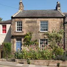
1 and 2 Temperley Place
789 m
Middle Shield House
864 m
Westburn
498 m
High Shield House
841 m
43, Hencotes
795 m
16 And 18, Hencotes
869 m
The 'Tannery', To South East Of High Shield House
868 m
Colfield House Temperley Place
769 m
Garden Wall At Rear Of Temperley Place (Number 5) Following Footpath To The Seal
772 m
Hencotes House
864 m
35, Hencotes
825 m
5 Temperley Place
763 m
Low Street Wall In Front Of Temperley Place (Number 4)
757 m
Highford Farmhouse
804 m
23 And 25, Hencotes
857 m
39 And 39A, Hencotes
810 m
37, Hencotes
818 m
The Former Hexham Hydropathic (Now Part Of Queen Elizabeth High School)
777 m
Courtyard Walls In Front Of Temperley Place (Number 5)
753 m
Woodley Field Farmhouse
663 m
Garden Wall Between Temperley Place
778 m
Bridge Over Cockshaw Burn
758 m
Bellevue
77 m
Bridge On Path South Of Cuddy's Lane, Also Over Halgut Burn
769 m
4 Temperley Place
767 m
17, Hencotes
882 mRecensioni
Ha visitato questo luogo? Tocchi le stelle per valutarlo e condividere la Sua esperienza o foto con la community! Provalo ora! Puoi annullarlo in qualsiasi momento.
Scopri tesori nascosti ad ogni viaggio!
Da piccoli caffè caratteristici a panorami nascosti, fuggi dalla folla e scova i posti che fanno davvero per te. La nostra app ti semplifica tutto: ricerca vocale, filtri furbi, percorsi ottimizzati e dritte autentiche da viaggiatori di tutto il mondo. Scaricala subito per vivere l'avventura sul tuo smartphone!

Un nuovo approccio alla scoperta turistica❞
— Le Figaro
Tutti i luoghi che meritano di essere esplorati❞
— France Info
Un’escursione su misura in pochi clic❞
— 20 Minutes