
Thornhill Tomb 15 Yards West North West Of East Malling
Thornhill Tomb 15 Yards West North West Of East Malling, building in East Malling and Larkfield, Tonbridge and Malling, Kent, UK
Posizione: East Malling and Larkfield
Coordinate GPS: 51.28752,0.44026
Ultimo aggiornamento: 13 novembre 2025 alle 01:05

Church of St James
34 m
4 and 6, Church Walk
64 m
Andrewes Tomb 4 Yards North East Of Malling Church
23 m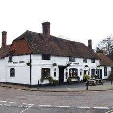
The King And Queen Public House
97 m
Tamarisk Cottage
294 m
Holly Cottage Raven Cottage
282 m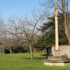
East Malling War Memorial
68 m
24 And 26, High Street
137 m
Kinross Cottage
272 m
45, High Street
156 m
Ingleside
98 m
Paris Farmhouse
454 m
Court Lodge
28 m
11, Mill Street
133 m
The Forge House
158 m
10-16, High Street
113 m
Part of an Iron Age enclosure and a minor Roman villa 128m SSE of the Church of St James
152 m
1-5, Mill Street
103 m
Ivy House Farmhouse
430 m
Wall To North East Of The Limes
327 m
6, The Rocks Road
229 m
69-75, Mill Street
436 m
Barn 30 Yards West Of Ivy House Farmhouse
433 m
Andrewes Tomb 10 Yards North Of East Malling Church
25 m
Andrewes Tomb 6 Yards North Of East Malling Church
24 m
The Limes
344 m
Andrewes Tomb 8 Yards North Of East Malling Church
24 m
The Vicarage
109 mRecensioni
Ha visitato questo luogo? Tocchi le stelle per valutarlo e condividere la Sua esperienza o foto con la community! Provalo ora! Puoi annullarlo in qualsiasi momento.
Scopri tesori nascosti ad ogni viaggio!
Da piccoli caffè caratteristici a panorami nascosti, fuggi dalla folla e scova i posti che fanno davvero per te. La nostra app ti semplifica tutto: ricerca vocale, filtri furbi, percorsi ottimizzati e dritte autentiche da viaggiatori di tutto il mondo. Scaricala subito per vivere l'avventura sul tuo smartphone!

Un nuovo approccio alla scoperta turistica❞
— Le Figaro
Tutti i luoghi che meritano di essere esplorati❞
— France Info
Un’escursione su misura in pochi clic❞
— 20 Minutes