
The Limes, architectural structure in East Malling and Larkfield, Tonbridge and Malling, Kent, UK
Posizione: East Malling and Larkfield
Coordinate GPS: 51.28481,0.43791
Ultimo aggiornamento: 25 novembre 2023 alle 01:32

Church of St James
349 m
Andrewes Tomb 4 Yards North East Of Malling Church
355 m
4 and 6, Church Walk
316 m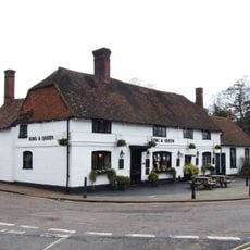
The King And Queen Public House
334 m
Tamarisk Cottage
54 m
Holly Cottage Raven Cottage
62 m
24 And 26, High Street
236 m
Kinross Cottage
75 m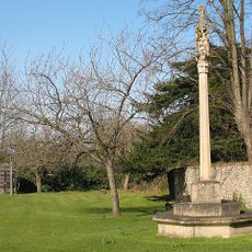
East Malling War Memorial
333 m
Ingleside
301 m
Ivy House Farmhouse
86 m
10-16, High Street
272 m
Part of an Iron Age enclosure and a minor Roman villa 128m SSE of the Church of St James
285 m
The Forge House
199 m
1-5, Mill Street
306 m
Paris Farmhouse
367 m
11, Mill Street
313 m
45, High Street
188 m
Court Lodge
354 m
Rock Farmhouse
334 m
Thornhill Tomb 15 Yards West North West Of East Malling
344 m
6, The Rocks Road
119 m
Wall To North East Of The Limes
21 m
Barn 30 Yards West Of Ivy House Farmhouse
92 m
The Vicarage
252 m
Andrewes Tomb 6 Yards North Of East Malling Church
358 m
Andrewes Tomb 8 Yards North Of East Malling Church
360 m
Andrewes Tomb 10 Yards North Of East Malling Church
362 mRecensioni
Ha visitato questo luogo? Tocchi le stelle per valutarlo e condividere la Sua esperienza o foto con la community! Provalo ora! Puoi annullarlo in qualsiasi momento.
Scopri tesori nascosti ad ogni viaggio!
Da piccoli caffè caratteristici a panorami nascosti, fuggi dalla folla e scova i posti che fanno davvero per te. La nostra app ti semplifica tutto: ricerca vocale, filtri furbi, percorsi ottimizzati e dritte autentiche da viaggiatori di tutto il mondo. Scaricala subito per vivere l'avventura sul tuo smartphone!

Un nuovo approccio alla scoperta turistica❞
— Le Figaro
Tutti i luoghi che meritano di essere esplorati❞
— France Info
Un’escursione su misura in pochi clic❞
— 20 Minutes