Hawarden Bridge

Accedi al tuo account

AroundUs è una mappa collaborativa di luoghi interessanti, costruita da esploratori curiosi come te. Cresce con ogni recensione, storia e foto che condividi.
Accedi per salvare i tuoi posti preferiti, contribuire con nuovi luoghi e creare percorsi personalizzati.
Continua con Google
Continua con Apple
Continua con X
Continua con Facebook
Continua con email
Continuando, accetti i nostri Termini e Condizioni e la nostra Informativa sulla Privacy
Creare un account
Aggiungi alla collezione
Mappa
Suggerisci una modifica
Condividere

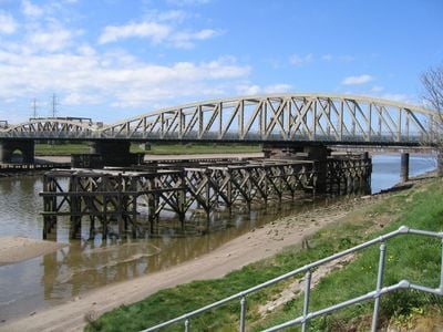
Hawarden Bridge, Ponte ferroviario a Sealand, Gran Bretagna.

Il ponte di Hawarden è un ponte ferroviario che attraversa il fiume Dee, collegando le linee ferroviarie tra l'Inghilterra e il Galles con una struttura d'acciaio. Il disegno del ponte permette il passaggio sicuro dei treni mentre mantiene il flusso naturale del fiume sottostante.

Il ponte si aprì nel 1889 come parte di un ambizioso progetto ferroviario che collegava più direttamente l'Inghilterra e il Galles. Rappresenta uno dei principali risultati tecnici della tarda era vittoriana nello sviluppo ferroviario britannico.

Il ponte rappresenta il patrimonio industriale del Flintshire, dove le influenze gallesi e inglesi si fondono nelle realizzazioni architettoniche dell'epoca vittoriana.

Il ponte è facilmente accessibile dalle stazioni ferroviarie vicine e serve il traffico quotidiano dei treni tra i due paesi. Poiché è un'infrastruttura ferroviaria attiva, i visitatori devono stare lontani dai binari e osservare da aree designate.

Al completamento, questa struttura si trovava tra i più lunghi ponti a campata unica dell'intero Regno Unito. L'approccio ingegneristico impiegato qui ha dimostrato tecniche e materiali molto avanzati per il periodo.

Posizione: Flintshire

Inaugurazione ufficiale: 3 agosto 1889

Altezza sopra il mare: 1 m

Coordinate GPS: 53.21720,-3.03320

Ultimo aggiornamento: 11 dicembre 2025 alle 12:04

Foto
Intorno a questo luogo
Wepre Park
Regno Unito

Wepre Park

2.4 km
Castello di Ewloe
Regno Unito

Castello di Ewloe

3 km
Deeside Leisure Centre
Regno Unito

Deeside Leisure Centre

1.2 km
Flintshire Bridge
Regno Unito

Flintshire Bridge

2.5 km
RAF Sealand
Regno Unito

RAF Sealand

2.4 km
Ponte del Giubileo
Regno Unito

Ponte del Giubileo

1.3 km
St Mark's Church, Connah's Quay
Regno Unito

St Mark's Church, Connah's Quay

2.1 km
St Ethelwold's Church, Shotton
Regno Unito

St Ethelwold's Church, Shotton

851 m
St David's Church, Connah's Quay
Regno Unito

St David's Church, Connah's Quay

1.4 km
Old Quay House Inn
Regno Unito

Old Quay House Inn

1.8 km
Deeside Library
Regno Unito

Deeside Library

1.1 km
Connah's Quay and Shotton War Memorial
Regno Unito

Connah's Quay and Shotton War Memorial

851 m
Gates, gatepiers and churchyard wall along north side of Shotwick Lane
Regno Unito

Gates, gatepiers and churchyard wall along north side of Shotwick Lane

3.5 km
Tombchest of Robert and Martha Ellison, 10 metres southwest of south corner of tower of Church of St Michael
Regno Unito

Tombchest of Robert and Martha Ellison, 10 metres southwest of south corner of tower of Church of St Michael

3.5 km
The Ship Public House
Regno Unito

The Ship Public House

1.6 km
Blessed Sacrament
Regno Unito

Blessed Sacrament

1.1 km
Sundial in the churchyard of St Michael
Regno Unito

Sundial in the churchyard of St Michael

3.5 km
Tombchest of James Phillips, 2 metres south of the sundial in the Churchyard of St Michael
Regno Unito

Tombchest of James Phillips, 2 metres south of the sundial in the Churchyard of St Michael

3.5 km
Tombchest of John Nevett Bennett, 5 metres west of south porch of St Michael's Church
Regno Unito

Tombchest of John Nevett Bennett, 5 metres west of south porch of St Michael's Church

3.5 km
Tombchest of Rev M Reay and 4 children, 8 metres south of south porch of Church of St Michael
Regno Unito

Tombchest of Rev M Reay and 4 children, 8 metres south of south porch of Church of St Michael

3.5 km
Tombchest of William Briscoe (died 1723) and others, 4 metres west of priest's door to St Michael's Church
Regno Unito

Tombchest of William Briscoe (died 1723) and others, 4 metres west of priest's door to St Michael's Church

3.5 km
Tombchest of William Briscoe (died 1704) and others, 5 metres southwest of priest's door to St Michael's Church
Regno Unito

Tombchest of William Briscoe (died 1704) and others, 5 metres southwest of priest's door to St Michael's Church

3.5 km
North Pair of Aircraft Hangars
Regno Unito

North Pair of Aircraft Hangars

2.5 km
South Pair of Aircraft Hangars
Regno Unito

South Pair of Aircraft Hangars

2.4 km
Lychgate at Church of St Mark
Regno Unito

Lychgate at Church of St Mark

2.1 km
Ferry Bank Farm
Regno Unito

Ferry Bank Farm

1.9 km
Ewloe Methodist Chapel
Regno Unito

Ewloe Methodist Chapel

3.2 km
Office Building, Corus Steelworks
Regno Unito

Office Building, Corus Steelworks

141 m
Mostra la mappa completa
Recensioni

Ha visitato questo luogo? Tocchi le stelle per valutarlo e condividere la Sua esperienza o foto con la community! Provalo ora! Puoi annullarlo in qualsiasi momento.

« Hawarden Bridge - Ponte ferroviario a Sealand, Gran Bretagna » è fornito da Around Us (it.aroundus.com). Le immagini e i testi sono tratti dal progetto Wikimedia con licenza Creative Commons. È possibile copiare, distribuire e modificare copie di questa pagina, alle condizioni stabilite dalla licenza, a condizione che questa nota sia chiaramente visibile.

Scopri tesori nascosti ad ogni viaggio!

Da piccoli caffè caratteristici a panorami nascosti, fuggi dalla folla e scova i posti che fanno davvero per te. La nostra app ti semplifica tutto: ricerca vocale, filtri furbi, percorsi ottimizzati e dritte autentiche da viaggiatori di tutto il mondo. Scaricala subito per vivere l'avventura sul tuo smartphone!

Around Us App Screenshot

Un nuovo approccio alla scoperta turistica

Le Figaro

Tutti i luoghi che meritano di essere esplorati

France Info

Un’escursione su misura in pochi clic

20 Minutes