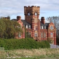
RAF Sealand, Base aerea militare a Flintshire, Galles.
RAF Sealand è una stazione aerea militare a Flintshire, Galles, con hangar, edifici amministrativi e impianti di addestramento specializzati distribuiti nei suoi terreni. La base comprende officine di manutenzione, camere bianche e camere di prova specializzate per i sistemi aeronautici avanzati.
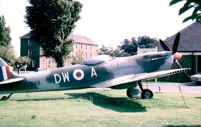
La stazione fu fondata nel 1916 come RFCS Shotwick e servì come campo di addestramento durante la Prima Guerra Mondiale. Nel 1924 si unì alla Royal Air Force e successivamente divenne un importante impianto di manutenzione e riparazione di aerei.
L'installazione militare ha ispirato musicisti locali quando la band Orchestral Manoeuvres in the Dark ha pubblicato una canzone chiamata Sealand nel 1981. Questo legame dimostra come il luogo sia diventato parte della cultura musicale regionale.
L'impianto si trova nel nord-est del Galles vicino al confine inglese ed è accessibile con i trasporti pubblici o in auto. I visitatori devono notare che rimane una base militare attiva dove l'accesso potrebbe essere limitato al personale autorizzato.
La base funge da centro di manutenzione globale per i caccia F-35 Lightning II, con camere bianche avanzate e strutture di prova radar. Questa specializzazione la rende un centro della tecnologia aeronautica moderna nel Regno Unito.
Coordinate GPS: 53.22243,-2.99796
Ultimo aggiornamento: 11 dicembre 2025 alle 12:04
Hawarden Bridge
2.4 km
Ponte del Giubileo
1.8 km
Shotwick Castle
1.6 km
Shotwick House
2.4 km
St Michael's Church, Shotwick
1.8 km
Shotwick Hall
2.1 km
St Bartholomew's Church, Sealand
2.1 km
Churchyard boundary wall, Church of St Bartholomew
2.1 km
Bridge Farmhouse
2.5 km
Gates, gatepiers and churchyard wall along north side of Shotwick Lane
1.8 km
Front garden walls and gatepiers at Shotwick Hall
2.1 km
Tombchest of Robert and Martha Ellison, 10 metres southwest of south corner of tower of Church of St Michael
1.8 km
Manor Farmhouse
1.9 km
Tombchest of John Nevett Bennett, 5 metres west of south porch of St Michael's Church
1.8 km
Former kitchen or bakehouse attached to north east corner of Shotwick Hall
2.1 km
Granary 30 metres east of Shotwicklodge Farmhouse
2.2 km
Sundial in the churchyard of St Michael
1.8 km
Tombchest of James Phillips, 2 metres south of the sundial in the Churchyard of St Michael
1.8 km
L-shaped ranges of farm buildings 60 metres north of Shotwick Hall
2.2 km
Greyhound Farmhouse
1.9 km
Tombchest of Rev M Reay and 4 children, 8 metres south of south porch of Church of St Michael
1.8 km
Tombchest of William Briscoe (died 1723) and others, 4 metres west of priest's door to St Michael's Church
1.8 km
South Pair of Aircraft Hangars
260 m
Tombchest of William Briscoe (died 1704) and others, 5 metres southwest of priest's door to St Michael's Church
1.8 km
Office Building, Corus Steelworks
2.3 km
Barn 70 metres north east of Shotwicklodge Farmhouse
2.2 km
North Pair of Aircraft Hangars
313 m
Ferry Bank Farm
1.4 kmHa visitato questo luogo? Tocchi le stelle per valutarlo e condividere la Sua esperienza o foto con la community! Provalo ora! Puoi annullarlo in qualsiasi momento.
Scopri tesori nascosti ad ogni viaggio!
Da piccoli caffè caratteristici a panorami nascosti, fuggi dalla folla e scova i posti che fanno davvero per te. La nostra app ti semplifica tutto: ricerca vocale, filtri furbi, percorsi ottimizzati e dritte autentiche da viaggiatori di tutto il mondo. Scaricala subito per vivere l'avventura sul tuo smartphone!
Un nuovo approccio alla scoperta turistica❞
— Le Figaro
Tutti i luoghi che meritano di essere esplorati❞
— France Info
Un’escursione su misura in pochi clic❞
— 20 Minutes