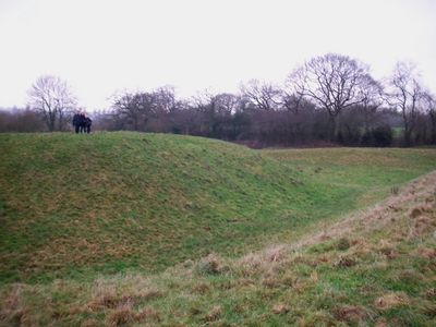
Shotwick Castle, Castello medievale a motta e bailey a Shotwick Park, Gran Bretagna.
Shotwick Castle è una fortificazione normanna a motta e recinto situata in Shotwick Park su una scarpata ripida sopra il fiume Dee. Il tumulo ha una forma esagonale in cima, con i resti di una torre di pietra sepolti sotto il terreno.
Hugh Lupus, conte di Chester, costruì la fortificazione nel 1093 per difendere il confine dal Galles. Rimase una posizione militare importante fino all'acquisizione della pace nel 1281.
Il passaggio da fortezza militare a parco di caccia reale dopo il 1327 riflette come cambiarono gli interessi della nobiltà. Il luogo divenne uno spazio dedicato allo svago invece di una difesa.
Il sito è difficile da raggiungere e si trova su terreni privati con accesso limitato. I visitatori dovrebbero informarsi in anticipo, poiché i resti si integrano naturalmente nel paesaggio.
Due corsi d'acqua ripidi fiancheggiano il tumulo sui suoi lati nord e sud per proteggerlo. Questi canali venivano allagati dal fiume durante le alte maree, creando una barriera d'acqua aggiuntiva.
Posizione: Shotwick Park
Posizione: Saughall and Shotwick Park
Inizio: 1093
Coordinate GPS: 53.22720,-2.97608
Ultimo aggiornamento: 8 dicembre 2025 alle 22:07
RAF Sealand
1.6 km
Shotwick House
883 m
St Michael's Church, Shotwick
1.8 km
Shotwick Hall
2 km
All Saints Church, Great Saughall
1.4 km
St Bartholomew's Church, Sealand
1.6 km
Churchyard boundary wall, Church of St Bartholomew
1.7 km
The Old Swinging Gate Inn
1.2 km
Bridge Farmhouse
1.1 km
Gates, gatepiers and churchyard wall along north side of Shotwick Lane
1.8 km
Front garden walls and gatepiers at Shotwick Hall
2 km
Tombchest of Robert and Martha Ellison, 10 metres southwest of south corner of tower of Church of St Michael
1.8 km
Manor Farmhouse
1.8 km
Tombchest of John Nevett Bennett, 5 metres west of south porch of St Michael's Church
1.8 km
Former kitchen or bakehouse attached to north east corner of Shotwick Hall
2 km
Sundial in the churchyard of St Michael
1.8 km
Greyhound Farmhouse
1.8 km
Tombchest of James Phillips, 2 metres south of the sundial in the Churchyard of St Michael
1.8 km
Granary 30 metres east of Shotwicklodge Farmhouse
941 m
L-shaped ranges of farm buildings 60 metres north of Shotwick Hall
2 km
Tombchest of Rev M Reay and 4 children, 8 metres south of south porch of Church of St Michael
1.8 km
Aldersey House
1.2 km
Tombchest of William Briscoe (died 1723) and others, 4 metres west of priest's door to St Michael's Church
1.8 km
Vicarage Farmhouse
1.8 km
North Pair of Aircraft Hangars
1.5 km
Tombchest of William Briscoe (died 1704) and others, 5 metres southwest of priest's door to St Michael's Church
1.8 km
South Pair of Aircraft Hangars
1.6 km
Footpath guidepost 25 metres south west of Bridge Farmhouse
1.2 kmHa visitato questo luogo? Tocchi le stelle per valutarlo e condividere la Sua esperienza o foto con la community! Provalo ora! Puoi annullarlo in qualsiasi momento.
Scopri tesori nascosti ad ogni viaggio!
Da piccoli caffè caratteristici a panorami nascosti, fuggi dalla folla e scova i posti che fanno davvero per te. La nostra app ti semplifica tutto: ricerca vocale, filtri furbi, percorsi ottimizzati e dritte autentiche da viaggiatori di tutto il mondo. Scaricala subito per vivere l'avventura sul tuo smartphone!
Un nuovo approccio alla scoperta turistica❞
— Le Figaro
Tutti i luoghi che meritano di essere esplorati❞
— France Info
Un’escursione su misura in pochi clic❞
— 20 Minutes