St Michael's Church, Shotwick

Accedi al tuo account

AroundUs è una mappa collaborativa di luoghi interessanti, costruita da esploratori curiosi come te. Cresce con ogni recensione, storia e foto che condividi.
Accedi per salvare i tuoi posti preferiti, contribuire con nuovi luoghi e creare percorsi personalizzati.
Continuando, accetti i nostri Termini e Condizioni e la nostra Informativa sulla Privacy
Aggiungi alla collezione
Mappa
Suggerisci una modifica
Condividere

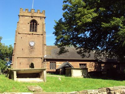
St Michael's Church, Shotwick, Chiesa medievale a Shotwick, Inghilterra

La chiesa in pietra presenta una torre gotica del 1500, un portale normanno e una navata che si estende per quattro campate.

La chiesa venne fondata nel 1050 vicino a un guado sul fiume Dee, segnando il confine naturale tra Inghilterra e Galles.

Gli interni conservano arredi storici, tra cui i più antichi banchi separati del Wirral e un pulpito a tre livelli del 1709.

Le funzioni religiose si svolgono ogni domenica alle 11:30, e l'edificio rimane aperto tutti i giorni dalle 9:00 alle 17:00.

Il cimitero ospita nove tombe di ufficiali della Royal Air Force della Prima Guerra Mondiale e strutture classificate Grado II.

Posizione: Puddington

Inizio: 11 secolo

Stile architettonico: English Gothic architecture, Norman architecture

Sito web: https://shotwick.org.uk

Coordinate GPS: 53.23880,-2.99510

Ultimo aggiornamento: 11 marzo 2025 alle 22:49

Interno
Interno
QRCode
Intorno a questo luogo
Mostra la mappa completa
RAF Sealand
Regno Unito

RAF Sealand

1.8 km
Shotwick Castle
Regno Unito

Shotwick Castle

1.8 km
Shotwick House
Regno Unito

Shotwick House

2.6 km
Shotwick Hall
Regno Unito

Shotwick Hall

284 m
Footpath Guidepost At Junction With Parkgate Road
Regno Unito

Footpath Guidepost At Junction With Parkgate Road

2.5 km
Bridge Farmhouse
Regno Unito

Bridge Farmhouse

2.9 km
Gates, gatepiers and churchyard wall along north side of Shotwick Lane
Regno Unito

Gates, gatepiers and churchyard wall along north side of Shotwick Lane

26 m
Front garden walls and gatepiers at Shotwick Hall
Regno Unito

Front garden walls and gatepiers at Shotwick Hall

274 m
Tombchest of Robert and Martha Ellison, 10 metres southwest of south corner of tower of Church of St Michael
Regno Unito

Tombchest of Robert and Martha Ellison, 10 metres southwest of south corner of tower of Church of St Michael

30 m
Manor Farmhouse
Regno Unito

Manor Farmhouse

107 m
Tombchest of John Nevett Bennett, 5 metres west of south porch of St Michael's Church
Regno Unito

Tombchest of John Nevett Bennett, 5 metres west of south porch of St Michael's Church

19 m
L-shaped ranges of farm buildings 60 metres north of Shotwick Hall
Regno Unito

L-shaped ranges of farm buildings 60 metres north of Shotwick Hall

353 m
Greyhound Farmhouse
Regno Unito

Greyhound Farmhouse

94 m
Sundial in the churchyard of St Michael
Regno Unito

Sundial in the churchyard of St Michael

25 m
Tombchest of James Phillips, 2 metres south of the sundial in the Churchyard of St Michael
Regno Unito

Tombchest of James Phillips, 2 metres south of the sundial in the Churchyard of St Michael

27 m
Footpath Guidepost At Junction Of Pipers Lane Opposite The White House
Regno Unito

Footpath Guidepost At Junction Of Pipers Lane Opposite The White House

1.9 km
Footpath guidepost 50m east of Heath farmhouse
Regno Unito

Footpath guidepost 50m east of Heath farmhouse

2.6 km
Granary 30 metres east of Shotwicklodge Farmhouse
Regno Unito

Granary 30 metres east of Shotwicklodge Farmhouse

1.5 km
Former kitchen or bakehouse attached to north east corner of Shotwick Hall
Regno Unito

Former kitchen or bakehouse attached to north east corner of Shotwick Hall

302 m
Tombchest of Rev M Reay and 4 children, 8 metres south of south porch of Church of St Michael
Regno Unito

Tombchest of Rev M Reay and 4 children, 8 metres south of south porch of Church of St Michael

15 m
Tombchest of William Briscoe (died 1723) and others, 4 metres west of priest's door to St Michael's Church
Regno Unito

Tombchest of William Briscoe (died 1723) and others, 4 metres west of priest's door to St Michael's Church

7 m
Vicarage Farmhouse
Regno Unito

Vicarage Farmhouse

58 m
Barn 70 metres north east of Shotwicklodge Farmhouse
Regno Unito

Barn 70 metres north east of Shotwicklodge Farmhouse

1.5 km
Footpath Guidepost 5 Metres North Of Top Lodge
Regno Unito

Footpath Guidepost 5 Metres North Of Top Lodge

1.7 km
Tombchest of William Briscoe (died 1704) and others, 5 metres southwest of priest's door to St Michael's Church
Regno Unito

Tombchest of William Briscoe (died 1704) and others, 5 metres southwest of priest's door to St Michael's Church

8 m
North Pair of Aircraft Hangars
Regno Unito

North Pair of Aircraft Hangars

1.5 km
South Pair of Aircraft Hangars
Regno Unito

South Pair of Aircraft Hangars

1.6 km
Gibbet Windmill
Regno Unito

Gibbet Windmill

2.7 km
Mostra la mappa completa

Recensioni

Ha visitato questo luogo? Tocchi le stelle per valutarlo e condividere la Sua esperienza o foto con la community! Provalo ora! Puoi annullarlo in qualsiasi momento.

« St Michael's Church, Shotwick: Chiesa medievale a Shotwick, Inghilterra » è fornito da Around Us (it.aroundus.com). Le immagini e i testi sono tratti dal progetto Wikimedia con licenza Creative Commons. È possibile copiare, distribuire e modificare copie di questa pagina, alle condizioni stabilite dalla licenza, a condizione che questa nota sia chiaramente visibile.

Scopri tesori nascosti ad ogni viaggio!

Da piccoli caffè caratteristici a panorami nascosti, fuggi dalla folla e scova i posti che fanno davvero per te. La nostra app ti semplifica tutto: ricerca vocale, filtri furbi, percorsi ottimizzati e dritte autentiche da viaggiatori di tutto il mondo. Scaricala subito per vivere l'avventura sul tuo smartphone!

Around Us App Screenshot

Un nuovo approccio alla scoperta turistica

Le Figaro

Tutti i luoghi che meritano di essere esplorati

France Info

Un’escursione su misura in pochi clic

20 Minutes