Shotwick Hall

Accedi al tuo account

AroundUs è una mappa collaborativa di luoghi interessanti, costruita da esploratori curiosi come te. Cresce con ogni recensione, storia e foto che condividi.
Accedi per salvare i tuoi posti preferiti, contribuire con nuovi luoghi e creare percorsi personalizzati.
Continua con Google
Continua con Apple
Continua con X
Continua con Facebook
Continua con email
Continuando, accetti i nostri Termini e Condizioni e la nostra Informativa sulla Privacy
Creare un account
Aggiungi alla collezione
Mappa
Suggerisci una modifica
Condividere

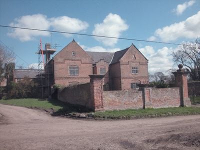
Shotwick Hall, Residenza storica Grade II* a Shotwick, Inghilterra

Shotwick Hall è una casa di campagna inglese costruita in mattoni con quoins in arenaria rossa, un tetto in ardesia gallese e grandi camini disposti secondo una pianta a forma di E su due piani. La proprietà include un giardino quadrato circondato da muri in mattoni con rivestimenti in arenaria rossa e pilastri di cancello posizionati a intervalli regolari.

Joseph Hockenhull ha commissionato la costruzione di Shotwick Hall nel 1662, sostituendo un precedente maniero fortificato situato a circa 150 metri a ovest. Questo trasferimento ha riflesso un passaggio verso uno stile di vita più aperto, allontanandosi dalla necessità di strutture difensive.

La scala interna presenta balaustre intagliate e un soffitto in stucco decorato con motivi di gigli e leoni, riflettendo i gusti artistici dei suoi ricchi proprietari. Questi ornamenti mostrano come le famiglie colte esibissero il loro status attraverso l'artigianato raffinato.

L'edificio e i terreni sono accessibili dai campi e dalle strade circostanti, facilitando l'orientamento per i visitanti che esplorano la proprietà. Il giardino recintato fornisce confini chiari, con i pilastri del cancello che servono come punti di riferimento utili quando si passeggia nel sito.

Un sito con fossato che segna la posizione del precedente maniero fortificato esiste ancora e misura approssimativamente 25 per 32 metri con terrapieni rialzati. Questo relitto archeologico si trova a mezzo metro sopra il livello del suolo ed è circondato da un fossato di circa 10 metri di larghezza, mostrando chiaramente dove si trovava la struttura difensiva precedente.

Posizione: Puddington

Coordinate GPS: 53.24130,-2.99426

Ultimo aggiornamento: 14 dicembre 2025 alle 15:40

Foto
Intorno a questo luogo
RAF Sealand
Regno Unito

RAF Sealand

2.1 km
Shotwick Castle
Regno Unito

Shotwick Castle

2 km
Shotwick House
Regno Unito

Shotwick House

2.7 km
St Michael's Church, Shotwick
Regno Unito

St Michael's Church, Shotwick

284 m
Footpath Guidepost At Junction With Parkgate Road
Regno Unito

Footpath Guidepost At Junction With Parkgate Road

2.2 km
Gates, gatepiers and churchyard wall along north side of Shotwick Lane
Regno Unito

Gates, gatepiers and churchyard wall along north side of Shotwick Lane

310 m
Front garden walls and gatepiers at Shotwick Hall
Regno Unito

Front garden walls and gatepiers at Shotwick Hall

20 m
Tombchest of Robert and Martha Ellison, 10 metres southwest of south corner of tower of Church of St Michael
Regno Unito

Tombchest of Robert and Martha Ellison, 10 metres southwest of south corner of tower of Church of St Michael

303 m
Manor Farmhouse
Regno Unito

Manor Farmhouse

220 m
Tombchest of John Nevett Bennett, 5 metres west of south porch of St Michael's Church
Regno Unito

Tombchest of John Nevett Bennett, 5 metres west of south porch of St Michael's Church

301 m
Greyhound Farmhouse
Regno Unito

Greyhound Farmhouse

228 m
Footpath Guidepost At Junction Of Pipers Lane Opposite The White House
Regno Unito

Footpath Guidepost At Junction Of Pipers Lane Opposite The White House

1.7 km
Sundial in the churchyard of St Michael
Regno Unito

Sundial in the churchyard of St Michael

307 m
Tombchest of James Phillips, 2 metres south of the sundial in the Churchyard of St Michael
Regno Unito

Tombchest of James Phillips, 2 metres south of the sundial in the Churchyard of St Michael

309 m
Granary 30 metres east of Shotwicklodge Farmhouse
Regno Unito

Granary 30 metres east of Shotwicklodge Farmhouse

1.6 km
Footpath guidepost 50m east of Heath farmhouse
Regno Unito

Footpath guidepost 50m east of Heath farmhouse

2.4 km
Former kitchen or bakehouse attached to north east corner of Shotwick Hall
Regno Unito

Former kitchen or bakehouse attached to north east corner of Shotwick Hall

19 m
L-shaped ranges of farm buildings 60 metres north of Shotwick Hall
Regno Unito

L-shaped ranges of farm buildings 60 metres north of Shotwick Hall

72 m
Tombchest of Rev M Reay and 4 children, 8 metres south of south porch of Church of St Michael
Regno Unito

Tombchest of Rev M Reay and 4 children, 8 metres south of south porch of Church of St Michael

295 m
Tombchest of William Briscoe (died 1723) and others, 4 metres west of priest's door to St Michael's Church
Regno Unito

Tombchest of William Briscoe (died 1723) and others, 4 metres west of priest's door to St Michael's Church

291 m
North Pair of Aircraft Hangars
Regno Unito

North Pair of Aircraft Hangars

1.8 km
Barn 70 metres north east of Shotwicklodge Farmhouse
Regno Unito

Barn 70 metres north east of Shotwicklodge Farmhouse

1.5 km
Tombchest of William Briscoe (died 1704) and others, 5 metres southwest of priest's door to St Michael's Church
Regno Unito

Tombchest of William Briscoe (died 1704) and others, 5 metres southwest of priest's door to St Michael's Church

292 m
Footpath Guidepost 5 Metres North Of Top Lodge
Regno Unito

Footpath Guidepost 5 Metres North Of Top Lodge

1.5 km
Vicarage Farmhouse
Regno Unito

Vicarage Farmhouse

231 m
South Pair of Aircraft Hangars
Regno Unito

South Pair of Aircraft Hangars

1.9 km
Gibbet Windmill
Regno Unito

Gibbet Windmill

2.6 km
Milepost, Parkgate Road, Woodbank
Regno Unito

Milepost, Parkgate Road, Woodbank

2.2 km
Mostra la mappa completa
Recensioni

Ha visitato questo luogo? Tocchi le stelle per valutarlo e condividere la Sua esperienza o foto con la community! Provalo ora! Puoi annullarlo in qualsiasi momento.

« Shotwick Hall - Residenza storica Grade II* a Shotwick, Inghilterra » è fornito da Around Us (it.aroundus.com). Le immagini e i testi sono tratti dal progetto Wikimedia con licenza Creative Commons. È possibile copiare, distribuire e modificare copie di questa pagina, alle condizioni stabilite dalla licenza, a condizione che questa nota sia chiaramente visibile.

Scopri tesori nascosti ad ogni viaggio!

Da piccoli caffè caratteristici a panorami nascosti, fuggi dalla folla e scova i posti che fanno davvero per te. La nostra app ti semplifica tutto: ricerca vocale, filtri furbi, percorsi ottimizzati e dritte autentiche da viaggiatori di tutto il mondo. Scaricala subito per vivere l'avventura sul tuo smartphone!

Around Us App Screenshot

Un nuovo approccio alla scoperta turistica

Le Figaro

Tutti i luoghi che meritano di essere esplorati

France Info

Un’escursione su misura in pochi clic

20 Minutes