Oldbury Hall, building in Ightham, Tonbridge and Malling, Kent, UK
Posizione: Ightham
Coordinate GPS: 51.28556,0.27517
Ultimo aggiornamento: 25 novembre 2023 alle 01:27
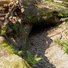
Oldbury rock shelters
410 m
The Old House, Ightham Common
683 m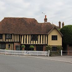
Old Forge House
825 m
Langleys
766 m
Stone House
775 m
The Bower House
674 m
Holly Tree Cottage
677 m
Rectory Cottage
515 m
Prestons Farmhouse
686 m
Old Stones
708 m
Yew Tree Cottage
714 m
The Chequers Public House
751 m
Petts Cottage
761 m
Methodist Chapel
508 m
Stone Cottage
768 m
Redwell
770 m
The Old Forge
614 m
Bank Cottage
777 m
The Old Cottage The Workhouse
783 m
Hortondene The Gallery
787 m
The Bank
788 m
The George And Dragon Public House
803 m
Bank Cottages
804 m
The Town House
809 m
Harrow Cottage
822 m
Oldbury Manor Farmhouse
250 m
Table Tomb In Churchyard Of Church Of St Peter 15 Yards South Of South Porch
826 m
Chest Tomb 10 Yards South Of South Porch
829 mRecensioni
Ha visitato questo luogo? Tocchi le stelle per valutarlo e condividere la Sua esperienza o foto con la community! Provalo ora! Puoi annullarlo in qualsiasi momento.
Scopri tesori nascosti ad ogni viaggio!
Da piccoli caffè caratteristici a panorami nascosti, fuggi dalla folla e scova i posti che fanno davvero per te. La nostra app ti semplifica tutto: ricerca vocale, filtri furbi, percorsi ottimizzati e dritte autentiche da viaggiatori di tutto il mondo. Scaricala subito per vivere l'avventura sul tuo smartphone!

Un nuovo approccio alla scoperta turistica❞
— Le Figaro
Tutti i luoghi che meritano di essere esplorati❞
— France Info
Un’escursione su misura in pochi clic❞
— 20 Minutes