34 And 36, Leigh Road, building in Hildenborough, Tonbridge and Malling, Kent, UK
Posizione: Hildenborough
Coordinate GPS: 51.21145,0.24784
Ultimo aggiornamento: 25 novembre 2023 alle 01:30
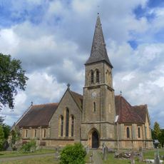
Parish Church of St John
897 m
Woodside Cottage
492 m
Memorial Cross About 11 Metres South East Of The Tower Of The Church Of St John
899 m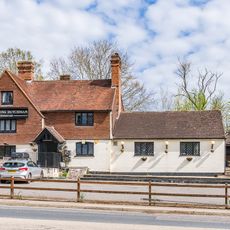
The Flying Dutchman Public House
248 m
Barn, Oast Kiln And Attatched Farmbuilding About 40 Metres North West Of Selbys
731 m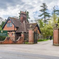
Lodge At The Entrance To Sackville School
855 m
Railway Bridge At Stocks Green
725 m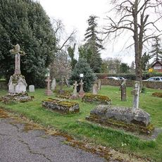
St John the Evangelist Churchyard
898 m
Coach House Immediately North East Of Oakhill Lawn
259 m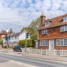
122, London Road
239 m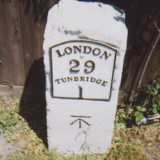
Milestone At 576 482
542 m
Drinking Fountain Opposite No 156, London Road, Including Cast Iron Railings
601 m
192 And 190, London Road
826 m
Angier Chest Tomb About 16 Metres North East Of The Chancel Of The Church Of St John
888 m
Quince Cottage
244 m
Herring Memorial About 12 Metres North East Of The Vestry Of The Church Of St John
895 m
Grove Cottage
770 m
180, London Road
794 m
182, London Road
798 m
Pembroke Lodge
683 m
Selbys Farmhouse
766 m
Cosling Memorial About 26 Metres North Of The West Wall Of The Chancel Of The Church Of St John
891 m
Oakhill Lawn
251 m
Sackville School
892 m
Oak Hill House
422 m
Hilden Cottages
513 m
The White House
479 m
Springwater Cottage
44 mRecensioni
Ha visitato questo luogo? Tocchi le stelle per valutarlo e condividere la Sua esperienza o foto con la community! Provalo ora! Puoi annullarlo in qualsiasi momento.
Scopri tesori nascosti ad ogni viaggio!
Da piccoli caffè caratteristici a panorami nascosti, fuggi dalla folla e scova i posti che fanno davvero per te. La nostra app ti semplifica tutto: ricerca vocale, filtri furbi, percorsi ottimizzati e dritte autentiche da viaggiatori di tutto il mondo. Scaricala subito per vivere l'avventura sul tuo smartphone!

Un nuovo approccio alla scoperta turistica❞
— Le Figaro
Tutti i luoghi che meritano di essere esplorati❞
— France Info
Un’escursione su misura in pochi clic❞
— 20 Minutes