
Red House Farmhouse
Red House Farmhouse, farmhouse in Cainscross, Stroud, Gloucestershire, UK
Posizione: Cainscross
Coordinate GPS: 51.74922,-2.25305
Ultimo aggiornamento: 25 novembre 2023 alle 01:30
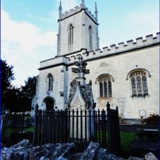
Church of St Matthew
866 m
Park End House
895 m
Ebley Chapel And Attached Boundary Walls To East
704 m
Long Court And Court Farmhouse With Boundary Wall And Gateway
872 m
Park End Cottage
867 m
Lock Up Opposite Court Farmhouse
851 m
More Hall Convent
582 m
1-3, Far Westrip
314 m
The Mill House
818 m
Barn Approximately 12 Metres East Of Humphries End House
684 m
Humphries End House
667 m
Stable And Cartsheds Approximately 10 Metres South East Of Court Farmhouse
847 m
Barn At Croft Farm
256 m
Wallace Cottage
853 m
Little Crybb The Cottages
567 m
The Cottages
559 m
Off Licence Cottages
276 m
Ivy Cottage The Cottages
545 m
Malt House
839 m
7 Far Westrip
352 m
Westrip Farm House
225 m
Rose Cottage
572 m
Stable To Westrip Farm
216 m
Barn To Westrip Farm
201 m
253, Westward Road
872 m
Westrip Lodge Including Iron Railings
201 m
288, Westward Road
874 m
1-3, Field Place
884 mRecensioni
Ha visitato questo luogo? Tocchi le stelle per valutarlo e condividere la Sua esperienza o foto con la community! Provalo ora! Puoi annullarlo in qualsiasi momento.
Scopri tesori nascosti ad ogni viaggio!
Da piccoli caffè caratteristici a panorami nascosti, fuggi dalla folla e scova i posti che fanno davvero per te. La nostra app ti semplifica tutto: ricerca vocale, filtri furbi, percorsi ottimizzati e dritte autentiche da viaggiatori di tutto il mondo. Scaricala subito per vivere l'avventura sul tuo smartphone!

Un nuovo approccio alla scoperta turistica❞
— Le Figaro
Tutti i luoghi che meritano di essere esplorati❞
— France Info
Un’escursione su misura in pochi clic❞
— 20 Minutes