
Stable Block Approximately 100 Metres West Of Ashtead Park House
Stable Block Approximately 100 Metres West Of Ashtead Park House, stable in Mole Valley, Surrey, UK
Posizione: Mole Valley
Coordinate GPS: 51.30786,-0.28902
Ultimo aggiornamento: 22 novembre 2025 alle 02:11
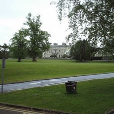
Ashtead Park
141 m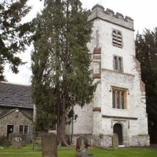
Church of St Giles, Ashtead
117 m
Bridgman Monument Approximately 8 Metres South Of Corner Of Chancel Of Church Of St Giles
95 m
Hamelot Monument Approximately 18 Metres South East Of Chancel Of Church Of St Giles
80 m
Bridge At Rookery Hill
313 m
Howard Cottage Ivy Cottage
729 m
The Howard Memorial Fountain
635 m
Two Tomb Chests Approximately 27 Metres South Of Church Of St Giles
80 m
Ashtead House
506 m
Coal Tax Post At Tq 200 579
679 m
The Old Rectory
678 m
Row Of 7 Headstones And 4 Footstones From Approximately 17 To Approximately 25 Metres South Of Church Of St Giles
85 m
Wheldon Headstone Approximately 8 Metres East Of Chancel Of Church Of St Giles
105 m
Walls And Balustrades To Terraced Garden On North Side Of Ashtead Park House
146 m
Sundial In Centre Of Forecourt In Front Of South Front Of Ashtead Park House
162 m
Gate Piers And Gates To Ashtead Park At Juncton Of Farm Lane And Pleasure Pit
424 m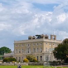
Ashtead Park House And Attached Balustrades
152 m
Group Of 4 Headstones And 1 Footstone Approximately 2 Metres South West Of Porch Of Church Of St Giles
111 m
Earthworks near St Giles' Church
233 m
Coal Tax Post Near Junction With Headley Road
645 m
Monument 5 Metres South Of Chancel Of Church Of St Giles
105 m
Group Of 7 Headstones And 5 Footstones From Approximately 17 To Approximately 25 Metres South Of Church Of St Giles
90 m
The Old Bakery
673 m
Ice House In Grounds Of Marsden Nurseries, Approximately 140 Metres North East Of Ashtead House
655 m
Walls Enclosing Walled Garden Beside Lane Opposite Ashtead House And North Of Headmasters House
526 m
Gatepiers With Associated Gates And Railings At Entrances To Rookery Hill And Drive To Church Of St Giles
368 m
Beckford Monument Approximately 8 Metres East Of Chancel Of Church Of St Giles
99 m
Headmaster's House
400 mRecensioni
Ha visitato questo luogo? Tocchi le stelle per valutarlo e condividere la Sua esperienza o foto con la community! Provalo ora! Puoi annullarlo in qualsiasi momento.
Scopri tesori nascosti ad ogni viaggio!
Da piccoli caffè caratteristici a panorami nascosti, fuggi dalla folla e scova i posti che fanno davvero per te. La nostra app ti semplifica tutto: ricerca vocale, filtri furbi, percorsi ottimizzati e dritte autentiche da viaggiatori di tutto il mondo. Scaricala subito per vivere l'avventura sul tuo smartphone!

Un nuovo approccio alla scoperta turistica❞
— Le Figaro
Tutti i luoghi che meritano di essere esplorati❞
— France Info
Un’escursione su misura in pochi clic❞
— 20 Minutes