
Walls Enclosing Walled Garden Beside Lane Opposite Ashtead House And North Of Headmasters House
Walls Enclosing Walled Garden Beside Lane Opposite Ashtead House And North Of Headmasters House, wall in Mole Valley, Surrey, UK
Posizione: Mole Valley
Coordinate GPS: 51.31232,-0.28651
Ultimo aggiornamento: 25 novembre 2023 alle 01:32
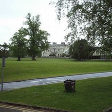
Ashtead Park
482 m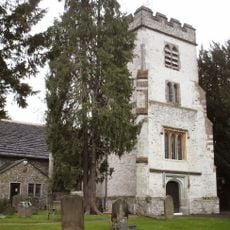
Church of St Giles, Ashtead
471 m
Bridgman Monument Approximately 8 Metres South Of Corner Of Chancel Of Church Of St Giles
476 m
Hamelot Monument Approximately 18 Metres South East Of Chancel Of Church Of St Giles
472 m
Bridge At Rookery Hill
321 m
Former Farm Building Approximately 2 Metres East Of Former Dairy Attached To Rear Of Park Farm House
254 m
Ashtead House
77 m
Two Tomb Chests Approximately 27 Metres South Of Church Of St Giles
506 m
Garden Wall With Gateway And Gate Approximately 6 Metres In Front Of Ashstead Farm House
236 m
Gate Piers And Gates Beside North Lodge
604 m
Sundial In Centre Of Forecourt In Front Of South Front Of Ashtead Park House
513 m
Wheldon Headstone Approximately 8 Metres East Of Chancel Of Church Of St Giles
461 m
Walls And Balustrades To Terraced Garden On North Side Of Ashtead Park House
466 m
Row Of 7 Headstones And 4 Footstones From Approximately 17 To Approximately 25 Metres South Of Church Of St Giles
501 m
Gate Piers And Gates To Ashtead Park At Juncton Of Farm Lane And Pleasure Pit
170 m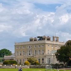
Ashtead Park House And Attached Balustrades
492 m
Beckford Monument Approximately 8 Metres East Of Chancel Of Church Of St Giles
465 m
Monument 5 Metres South Of Chancel Of Church Of St Giles
481 m
Group Of 4 Headstones And 1 Footstone Approximately 2 Metres South West Of Porch Of Church Of St Giles
488 m
Headmaster's House
153 m
Ice House In Grounds Of Marsden Nurseries, Approximately 140 Metres North East Of Ashtead House
170 m
Ashtead Park Farm House
245 m
Group Of 7 Headstones And 5 Footstones From Approximately 17 To Approximately 25 Metres South Of Church Of St Giles
509 m
Balustrade Enclosing Forecourt In Front Of South Front Of Ashtead Park House
510 m
Earthworks near St Giles' Church
447 m
Stable Block Approximately 100 Metres West Of Ashtead Park House
526 m
Gatepiers With Associated Gates And Railings At Entrances To Rookery Hill And Drive To Church Of St Giles
574 m
Coal Tax Post Near Junction With Headley Road
359 mRecensioni
Ha visitato questo luogo? Tocchi le stelle per valutarlo e condividere la Sua esperienza o foto con la community! Provalo ora! Puoi annullarlo in qualsiasi momento.
Scopri tesori nascosti ad ogni viaggio!
Da piccoli caffè caratteristici a panorami nascosti, fuggi dalla folla e scova i posti che fanno davvero per te. La nostra app ti semplifica tutto: ricerca vocale, filtri furbi, percorsi ottimizzati e dritte autentiche da viaggiatori di tutto il mondo. Scaricala subito per vivere l'avventura sul tuo smartphone!

Un nuovo approccio alla scoperta turistica❞
— Le Figaro
Tutti i luoghi che meritano di essere esplorati❞
— France Info
Un’escursione su misura in pochi clic❞
— 20 Minutes